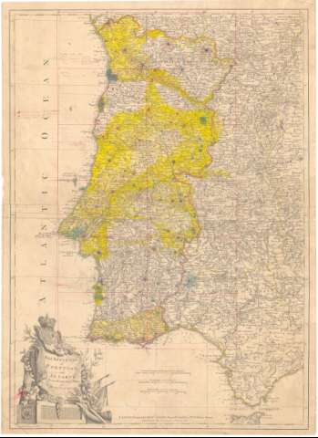
Kingdoms of Portugal and Algarve from Zannoni's Map


 Disponible Holdings
 Section: Maps, plans and nautical charts
Uniform title: Portugal. Mapas generales. 1:1300000 (1787)
Title: Kingdoms of Portugal and Algarve from Zannoni's Map / by J. Lodge Geographer
Material or type of resouce Area: Escala [ca. 1:300000], 15 Common Leagues of Portugal 18 to a Degree [= 7,5 cm] ; [proyec. cónica]
Publication: London : Printed for Robt. Sayer, Map and Printfeller N. 53 Fleet Street, 1787
Physical description: 1 mapa : col., montado sobre tela ; 59,2x43,5 cm
Content type: Imagen cartográfica
Media type: computadora
Carrier type: recurso en línea
Notes: Comprende Portugal, Extremadura y parte de Galicia, Castilla y León, Castilla La Mancha y Andalucia
Escalas gráficas de leguas marinas de 20 al grado [= 6,1 cm], Millas británicas de 69 1/2 al grado [= 6,3 cm]. Coordenadas referidas al meridiano de Hierro (E7°20'-E12°50'/N42°03'-N35°42'). Red geográfica de 1° en 1°
Anotaciones a lápiz indicando núcleos de población y a tinta roja indicando las comarcas nuevas y antiguas
Coloreados en amarillo algunos límites administrativos
Título enmarcado en cartela barroca con escudo real y cristo en cruz adornado con motivos florales
Materia / lugar / evento: Mapas generales
Triangulación
1787
UDC: 912:528.41(469+460-15)'1787'
(460-15)
Type of publication:
 Maps
Maps
Rights:
Préstamo:
Disponible
