Karte von Mittel-America und West-Indien : nebst den...


 Maps, plans and nautical charts
Karte von Mittel-America und West-Indien : nebst den übrigen Küstenstaaten, welche das americanische mittelmener... (1849)
Maps, plans and nautical charts
Karte von Mittel-America und West-Indien : nebst den übrigen Küstenstaaten, welche das americanische mittelmener... (1849)
 Disponible Holdings
 Section: Maps, plans and nautical charts
Uniform title: Caribe (Mar). Mapas generales (1849). 1:4500000
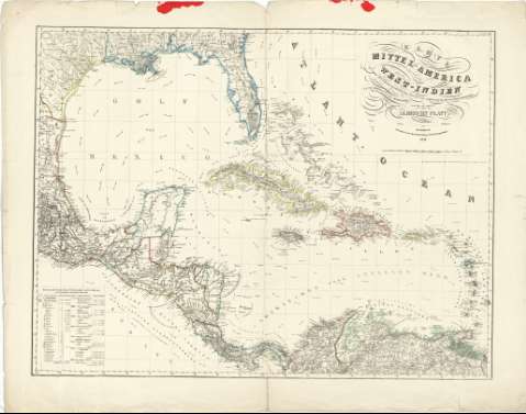
Title: Karte von Mittel-America und West-Indien : nebst den übrigen Küstenstaaten, welche das americanische mittelmener begreuzen nach Berghaus und Arrowsmith / gezeichnet und entworfen vou Albrecht Platt
Material or type of resouce Area: Escala 1:4500000 ; [Proyección Mercator]
Publication: Magdeburg : Zuhaben in der Kunsthandung von Fr. Kaegelman, 1849
Physical description: 1 mapa : col. ; 68 x 90 cm
Content type: Imagen cartográfica
Media type: computadora
Carrier type: recurso en línea
Notes: Comprende el Golfo de México, América Central y región del Caribe, incluida la zona septentrional de América del Sur, destacándose, diferenciadas por colores, las posesiones coloniales inglesas, españolas, francesas, holandesas, danesas y suecas, así como las fronteras entre estados independientes
Basado en trabajos de Berghaus y Arrowsmith
Escala dada como fracción representativa y en forma gráfica, de 100 millas geográficas [= 15'8 cm]. Coordenadas referidas al meridiano de París (O 102°00'-O 62°00'/N 30°50'-N 7°30'). Red geográfica de 1° en 1°
Relieve representado por normales
Señala, además, la dirección y recorrido de las corrientes marinas
En el ángulo inferior derecho presenta una tabla descriptiva donde se indica el color utilizado para distinguir las colonias de cada país, su extensión y número de habitantes
Título decorado con filigranas
Materia / lugar / evento: Mapas generales
Corrientes oceánicas
Colonias
Fronteras
Elementos decorativos
Golfos
1849
América Central
México
Other authors: Platt, Albrecht
Kaegelman, Fr
UDC: (728/729)
Type of publication:
Maps
Rights:
Préstamo:
Disponible
