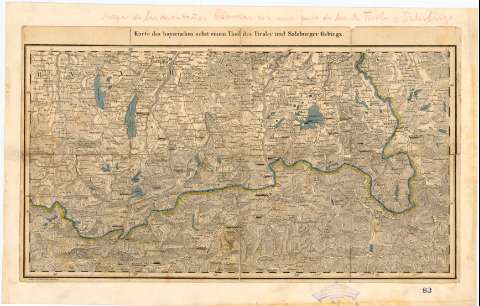
Karte des bayerischen nebst einem Theil des Timles und...


 Maps, plans and nautical charts
Karte des bayerischen nebst einem Theil des Timles und Salzburger Gebirgs (18--?)
Maps, plans and nautical charts
Karte des bayerischen nebst einem Theil des Timles und Salzburger Gebirgs (18--?)
 Disponible Holdings
 Section: Maps, plans and nautical charts
Uniform title: ALEMANIA. SE. Mapas generales. 1:520000 (18--?)
Title: Karte des bayerischen nebst einem Theil des Timles und Salzburger Gebirgs / Cravirt v. Friedr Piller, Munchen
Material or type of resouce Area: [Ca. 1:520000]
Publication: [Deutschland : [Editor no identificado], 18--?]
Physical description: 1 mapa : col., montado sobre tela ; 23,5 x 40,4 cm en h. de 27,6 x 43,3 cm
Content type: Imagen cartográfica
Media type: computadora
Carrier type: recurso en línea
Notes: Escala hallada a partir de treinta minutos de la latitud [= 10,8 cm]. Proyec. cónica. Coordenadas referidas,al parecer, al meridiano de Hierro (E 28°20'-E 31°00'/N 40 08'-N 47 47'). Red geográfica de 30' en 30'
Relieve representado por normales
Indica fronteras en azul y amarillo
Procede de la "Colección Rico y Sinobas", n. 83
Other authors: Piller, Friedr
UDC: 912:341.222(430-12)'18'
(436-16)
Type of publication:
Maps
Rights:
Préstamo:
Disponible
