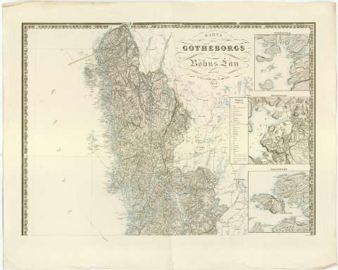
Karta ofver Gotheborgs och Bohus Lan


Section: Maps, plans and nautical charts
Uniform title: GOTEBORG OCH BOHUS (Suecia). Mapas generales. 1:200000 (1859)
Title: Karta ofver Gotheborgs och Bohus Lan / F. Holm<. Kjobenhavn [grab.]
Material or type of resouce Area: Escala 1:200000 ; [proyec. cónica]
Publication: [Stockholm ?] : utgifven af Topografiska Corpsen, 1859
Physical description: 1 mapa en 2 h. : col. ; 136x83 cm en h. de 69x83 cm o menos
Content type: Imagen cartográfica
Media type: computadora
Carrier type: recurso en línea
Notes: Coordenadas referidas, al parecer, al meridiano de Hierro (E28#15'-E30#35'/N59#05'-N57#10') y a otro meridiano que no se especifica. Red geográfica de 30' en 30'
Relieve representado por normales y sombreado
Relación de los principales distritos o zonas indicados por clave numérica
Tabla de signos convencionales para indicar núcleos de población de diferente categoria, iglesias, carreteras, faros etc...
En el ángulo superior derecho, 'Geogr. langden ar raknad fran Stockholms Observatorium, belaget 35#43'19''5 ost fran Ferro'
Indica límites de divisiones administrativas a color
Inserta : Stromstad ; Uddevalla ; Marstrand ; Gotheborg, todos ellos a escala 1:20000
Materia / lugar / evento: Mapas generales
Divisiones administrativas
1859
Göteborg
Other authors: Holm
Kjobenhavn
UDC: 912(485-328 Goteborg och Bohus)'1859'
(485 Gothenburg)
Type of publication:
 Maps
Maps
Rights:
Préstamo:
 Disponible
