China sea : northern portion, compiled from the latest...


 Maps, plans and nautical charts
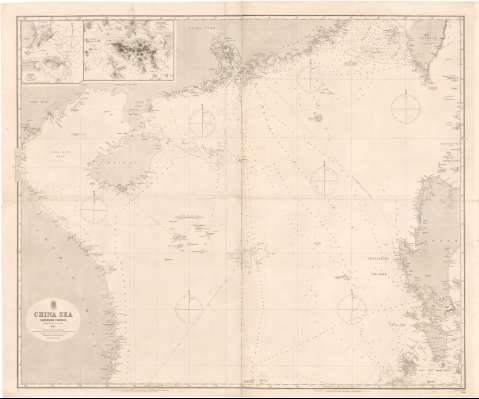
China sea : northern portion, compiled from the latest surveys 1867 (Augt. 30th. 1867)
Maps, plans and nautical charts
China sea : northern portion, compiled from the latest surveys 1867 (Augt. 30th. 1867)
 Disponible Holdings
 Section: Maps, plans and nautical charts
Uniform title: CHINA MERIDIONAL (Mar). Cartas náuticas (1867). 1:1600000
Title: China sea : northern portion, compiled from the latest surveys 1867 / engraved by J. & C. Walker
Material or type of resouce Area: Escala [ca. 1:1600000] ; [proyec. de Mercator] (E105°50'-E122°00'/N24°00'-N11°20')
Publication: London : Admiralty, Augt. 30th. 1867
Physical description: 1 carta náutica ; 95,5x114 cm en h. de 101,5x121,5 cm, pleg. en 51x61 cm
Content type: Imagen cartográfica
Media type: computadora
Carrier type: recurso en línea
Notes: Escala hallada a partir de un grado de latitud [= 7,2 cm]. Red geográfica de 2° en 2°. Orientado con estrella en cuadrante. Indica ángulo de declinación magnética
Indica veriles, bajos y sondas batimétricas en brazas. Clave hidrográfica para determinar la calidad del fondo
Señala enfilaciones para la entrada a puerto
Inserta : Macao / by W.A. Read. - Escala [ca. 1:64000], 10 cables [= 2,9 cm]. Hong Kong / surveyed by E. Belcher. - Escala [ca. 1:124000], 2 sea miles [= 3 cm]
Other authors: Belcher, Edward
Read, W.A
Gran Bretaña. Admiralty
J. & C. Walker
UDC: 912:[551.46:551.468:551.42](26 China Meridional)'1867'
26 China Meridional
Type of publication:
Maps
Rights:
Préstamo:
Disponible
