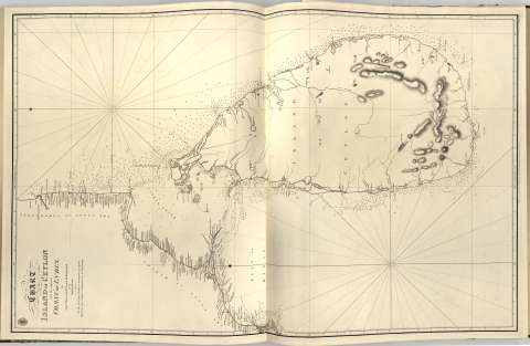
Chart of the Island of Ceylan with the adjacent coast of...


 Maps, plans and nautical charts
Chart of the Island of Ceylan with the adjacent coast of India (1872)
Maps, plans and nautical charts
Chart of the Island of Ceylan with the adjacent coast of India (1872)
 Disponible Holdings
 Section: Maps, plans and nautical charts
Uniform title: Sri Lanka. Cartas nauticas (1822). 1:5000000
Title: Chart of the Island of Ceylan with the adjacent coast of India / by Captn. Heywood ; Mr. Wedgburg of the Bombay Marine ; J. Walker script
Material or type of resouce Area: Escala [ca. 1:5.000.000] (E78°20'-E82°10'/N11°35'-N5°35')
Publication: [London ?] : Published according to Art of Parliament by Capt. Hurd R.N. Hydrographer to the Admiralty, 1872
Physical description: 1 carta nautica ; 72x62 cm en h. de 99x66 cm, pleg en 49x66 cm
Content type: Imagen cartográfica
Media type: computadora
Carrier type: recurso en línea
Notes: En : 'Chart Red Sea'
Orientado con lis en nudo de rumbos
Relieve representado por sondas batimetricas
Indica veriles bajos y fondeaderos
Sello de 'Hydrographical Officer'
Other authors: Heywood, Peter
Wedgburgh
Walker, John, fl. 1759-1830
Hurd, Thomas
UDC: 912:[551.46:551.42:551.468](540 Sri Lanka)'1822'
540 Sri Lanka
Type of publication:
Maps
Rights:
Préstamo:
Disponible
