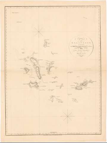
Chart of the Galapagos


Section: Maps, plans and nautical charts
Title: Chart of the Galapagos / Surveyed in the Merchant-Ship Rattler, and Drawn By Capt, James Colnett of the Royal Navy, in 1793-1794 ; Engraved by T. Foot, Weston Place, St. Pancras
Material or type of resouce Area: Escala [ca. 1:650000 ; proy. Mercator] (O 92°09'00'' -- O 88°57'30'' / N 1°53'52'' -- S 2°38'19'')
Publication: London : Published... by A. Arrowsmith, 10 Soho Square, 1st. January 1798
Physical description: 1 map. ; 77 x 58 cm, pleg. 64 x 43 cm
Notes: Presenta el archipiélago de las Galápagos, si bien varias de sus islas aparecen representadas de forma parcial, pues sólo lo está aquella parte que fue reconocida por el Rattler
Escala hallada a partir de 1 grado de latitud [= 17 cm]. Red geográfica de 1° en 1°.- Orientado con dos nudos de 32 vientos. Señalización en algunos puntos de la variación magnética observada
Relieve representado por normales
Indica sondas batimétricas, bajos y fondeaderos, así como la linea de derrota seguida por el mencionado barco
Materia / lugar / evento: Cartas náuticas
Expediciones geográficas
Derroteros
Buques
1798
Ecuador
Other authors: Colnett, James
Arrowsmith, Aaron, 1750-1823
Foot, Thomas
UDC: (866.4 Galápagos)
Type of publication:
 Maps
Maps
Rights:
Préstamo:
 Disponible
