Central Asia : Mapped on The Basis of The Most Receut...


 Maps, plans and nautical charts
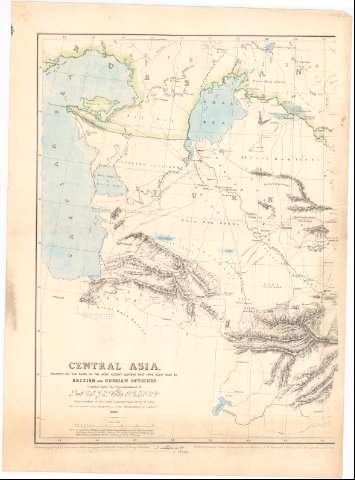
Central Asia : Mapped on The Basis of The Most Receut Surveys That have been made by British and Russian Officers (1866)
Maps, plans and nautical charts
Central Asia : Mapped on The Basis of The Most Receut Surveys That have been made by British and Russian Officers (1866)
 Disponible Holdings
 Section: Maps, plans and nautical charts
Uniform title: Oriente Medio. Mapas generales. 1:3.500.000 (1866)
Title: Central Asia : Mapped on The Basis of The Most Receut Surveys That have been made by British and Russian Officers / Compiled under The Superintendence of Lieut. Col J.Y. Walker R.E.J.R.S.L. superintendent of The Great Trigonometrical Survey of India by W.H. Scott. Civil Assitant and Chief Dauchtsman, C.T. survey
Material or type of resouce Area: Escala [Ca. 1:3.500.000] ; [proyec. conica] (E53°0'-E81°25)
Publication: [London ?] : Hill Sketching by Captn. H.H. Godwin, 1866
Physical description: 1 mapa en 2 h. : col ; 69x101 cm en h. de 79x109 cm pleg 79x58 cm
Content type: Imagen cartográfica
Media type: computadora
Carrier type: recurso en línea
Notes: Relieve representado por normales. Red geográfica de 2° en 2°
Nota sobre la linea inglesa de Boundary. Notas manuscritas en color al parecer de D. Francisco Coello.
Sello en seco de 'Topographical Department India'
Materia / lugar / evento: Mapas generales
URSS
Irán
Afganistán
Other authors: Walker, J. Y
Scott W.H
Godwin, H.H
UDC: 912(5-011)'1866'
(47)
(55)
(581)
Type of publication:
Maps
Rights:
Préstamo:
Disponible
