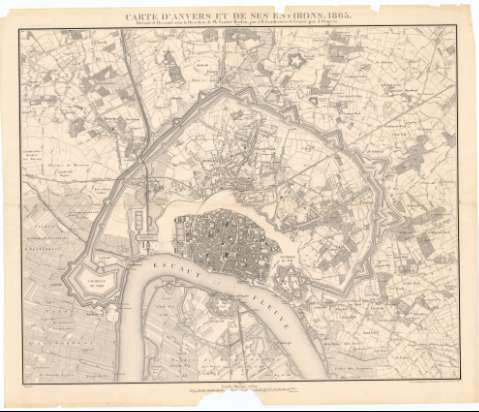
Carte d'Anvers et de ses environs


Section: Maps, plans and nautical charts
Uniform title: AMBERES (Bélgica). Planos de población. 1:10000 (1865)
Title: Carte d'Anvers et de ses environs / dressée et dessinée sous la direction de Ph. Vander Maelen, par J.B. Vanderwee et gravée par J. Ongers
Material or type of resouce Area: 1:10000
Publication: Bruxelles : Etablissement Geographique, 1865
Physical description: 1 plano ; 75 x 92 cm en h. de 84,5 x 99,3 cm, pleg. en 84,5 x 50,3 cm
Content type: Imagen cartográfica
Media type: computadora
Carrier type: recurso en línea
Notes: Escalas gráficas de 2000 metros [= 19,7 cm] y 2 Kilómetros [= 19,7 cm]
Relieve representado por curvas de nivel de 1 metro de equidistancia
Materia / lugar / evento: Planos de población
Ciudadelas
Fortificaciones
1865
Bélgica
Other authors: Vanderwee, B
Vandermaelen, Philippe, 1795-1869
Ongers, J
Etablissement Geographique de Bruxelles
UDC: 912:314(493 Amberes)'1865'(084.3)
912:[725.183:623.2](493 Amberes) '1865'
Type of publication:
 Maps
Maps
Rights:
Préstamo:
 Disponible
