A New Chart of the Coast of Africa Between Cape Blanco...


 Maps, plans and nautical charts
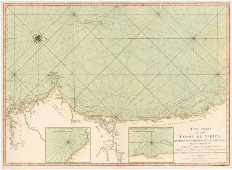
A New Chart of the Coast of Africa Between Cape Blanco and River Gambia from the observations of Messes. D' Aprés... (12th May 1794)
Maps, plans and nautical charts
A New Chart of the Coast of Africa Between Cape Blanco and River Gambia from the observations of Messes. D' Aprés... (12th May 1794)
 Disponible Holdings
 Section: Maps, plans and nautical charts
Uniform title: AFRICA. Cartas náuticas (1794). 1:1500000
Title: A New Chart of the Coast of Africa Between Cape Blanco and River Gambia from the observations of Messes. D' Aprés and De Fleurieu : With Improvements & Additions from the Draught of that Coast made by Guillaume Dupond a French Pilot, & Communicated by Sr. Hugh Pallisser
Material or type of resouce Area: [Ca. 1:1500000]
Publication: London : Published by Laurie & Whittle, n 53, Fleet Street, as the Act directs, 12th May 1794
Physical description: 1 carta náutica : col., montada sobre tela ; 50 x 68,5 cm
Content type: Imagen cartográfica
Media type: computadora
Carrier type: recurso en línea
Notes: Escala hallada a partir de un grado de latitud [= 7,8 cm]. Coordenadas referidas al meridiano de Londres (O 20°15'-O 14°15'/N 21°15'/N 12°45°). Orientado con lis en rosa de 16 vientos prolongados
Relieve de perfil
Indica veriles, bajos, fondeaderos y sondas batimétricas
Inserta: "The Coast Adjacent to Goree". Escala [ca. 1:470000], 5 leguas [= 5,9 cm] ; "The Bay of Portendids or Joura". Escala [ca. 1:1700000], 1 legua [= 6,5 cm]
Other authors: Dupond, Guillaume
Pallisser, Hugh
Mannevillette, Jean Baptiste Nicolas Denis d'Après de
Fleurieu, Charles Pierre Claret, comte de, 1738-1810
Robert Laurie and James Whittle
UDC: 912:551.46(6-15)'1794'
6-15
Type of publication:
Maps
Rights:
Préstamo:
Disponible
