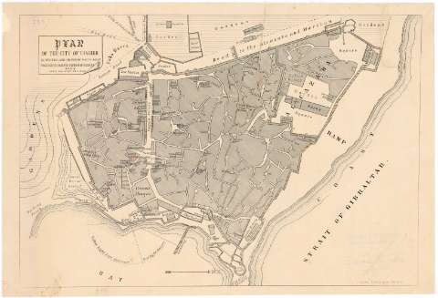
Plan of the city of Tanger


Section: Maps, plans and nautical charts
Uniform title: TANGER (Marruecos). Planos de población. 1:2500 (1888)
Title: Plan of the city of Tanger / surveyed and drawn by Kaid E. Silva engineer to H.S.M. the Emperor of Moroco
Material or type of resouce Area: Escala [1:2500], 200 feet to 1 inch
Publication: Gibraltar : J. Spitzer, 1888
Physical description: 1 plano : montado sobre tela ; 27,6x41 cm
Content type: Imagen cartográfica
Media type: computadora
Carrier type: recurso en línea
Notes: Orientado con flecha
Materia / lugar / evento: Planos de población
1888
Other authors: Silva, E
Spitzer, J
UDC: 912:314(64 Tanger)'1888'(084.3)
64 Tanger
Type of publication:
 Maps
Maps
Rights:
Archivo Cartográfico de Estudios Geográficos del Centro Geográfico del Ejército
Collection: PCGE — Location: AR — Call number: Ar.Q-T.9-C.4-150 — Código de barras: 2211847
Préstamo:
 Disponible

© Ministerio de Defensa de España
P. de la Castellana, 109 28071 Madrid.
Tlf: (34) 91 395 50 00
Email: patrimonio.cultural@oc.mde.es