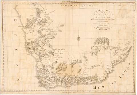
Carte de la Partie Méridionale de L'Afrique : Pour...


 Maps, plans and nautical charts
Carte de la Partie Méridionale de L'Afrique : Pour servir dintelligence aux deux Voyages de Levaillant (1795?)
Maps, plans and nautical charts
Carte de la Partie Méridionale de L'Afrique : Pour servir dintelligence aux deux Voyages de Levaillant (1795?)
 Disponible Holdings
 Section: Maps, plans and nautical charts
Uniform title: AFRICA. Mapas generales (1795). 1:2200000
Title: Carte de la Partie Méridionale de L'Afrique : Pour servir dintelligence aux deux Voyages de Levaillant / Levaillant delin ; Perriez sculp
Material or type of resouce Area: [Ca. 1:2200000] ; [proyec. escenográfica meridiana]
Publication: Paris : Se trouve chez H.J. Jansen et Perronneau Imprimeuis. Libraires, [1795?]
Physical description: 1 mapa : montado sobre tela ; 63 x 90,2 cm
Content type: Imagen cartográfica
Media type: computadora
Carrier type: recurso en línea
Notes: Escala hallada a partir de un grado de latitud [= 5 cm]. Coordenadas referidas al meridiano de Hierro (E 30°-E 49°/S 25°-S 5°) y referidas al meridiano de París. Red geográfica de 1° en 1°. Orientado con flecha en rosa de 8 vientos
Relieve de perfil
Indica carreteras y masas forestales
Other authors: Levaillant, F
Perrier, fl. 1760-1824
Chez Jansen et Perronneau (París)
UDC: 912(6-13)'1850/1859'
6-13
Type of publication:
Maps
Rights:
Préstamo:
Disponible
