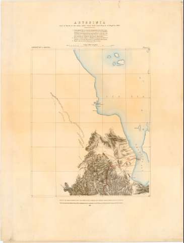
Abyssinia : Line of March of the Army under Lieut. Gen....
Section: Maps, plans and nautical charts
Uniform title: ETIOPIA. Mapas generales. 1869. 1:157000 (1868)
Title: Abyssinia : Line of March of the Army under Lieut. Gen. Lord Napier of Magdala 1868 / surveyed by Lieut. Cartier. R.E. surveyor, G.T. survey of India, assisted by Lieuts. A.E. Dummler, R.E. and T.H. Holdich R.E., assistant surveyors ; drawn by Lieut. Holdich, R.E.
Material or type of resouce Area: Escala [ca. 1:157000], 20 Miles [= 12,5 cm] ; [proyec. conica]
Publication: Southampton : Photozincographed at the Ordnance Survey Office, 1869
Physical description: 1 mapa en 5 h : col. ; 44x36 cm en h. de 72x55 cm
Content type: Imagen cartográfica
Media type: computadora
Carrier type: recurso en línea
Notes: Escala grafica de 16 millas [= 13 cm] Coordenadas referidas al parecer al meridiano de Paris (E39°0'-E39°50'/N15°39'-N12°39'). Red geografica de 10' en 10'
Relieve representado por normales y puntos acotados. Sondas batimetricas
Indica fondeaderos
Nota sobre la Triangulación y la situación de algunas zonas en el mapa
Sello en seco 'Topographical Departm war Office' y sello en seco del Deposito de la Guerra
Materia / lugar / evento: Mapas generales
Estrategia
Topónimos antiguos
Itinerarios
1868
Etiopía
UDC: 912:355.43(63-17)'1869'
63-17
Type of publication:
![]() Maps
Maps
Préstamo:
![]() Disponible
Disponible


