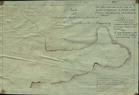
Croquis del Puerto de Tumanao : (Isla Sarangani)


 Disponible Holdings
 Section: Maps, plans and nautical charts
Uniform title: TUMANAO (Filipinas) (Puerto). Cartas náuticas. 1:14800 (1888)
Title: Croquis del Puerto de Tumanao : (Isla Sarangani) / Levantado en 1888 por el Comandante del cañonero "Prueba" de Juan Gastardi
Material or type of resouce Area: Escala 1:14.800. 1000 metros [= 6,7 cm]
Publication: 1888
Physical description: 1 carta náutica : ms. ; 14,2 x 20,8 cm
Content type: Imagen cartográfica
Media type: computadora
Carrier type: recurso en línea
Notes: Clave alfabética
Relieve representado por normales y sombreados. Indica sondas batimétricas, fondeaderos y veriles
Nota en el margen inferior izquierdo: "13 Abril 1888 J. Gastardi, T.N."
Nota en el margen superior izquierdo: "Es copia. El Ayudante Secretario, Trinidad Natrez"
Escala también expresada en media milla [= 6,2 cm]
Orientado con nudo de rumbos y los cuatro punto cardinales
La sonda está expresada en metros al nivel de la bajamar con amplitud de 2,5 m
En el texto: "Este plano, reducción de otro en tela, ha servido de original para la plancha nº 845 que contiene varios planos de la isla de Mindanao y adyacentes"
Aparece el sello de la División del Sur
Materia / lugar / evento: Cartas náuticas
Sarangani (Isla)
Tumanao (Fondeadero)
Genre / form: Manuscritos
Other authors: Gastardi, Juan
UDC: 912:551.46]:627.22(914:26.04)"1788"
914:26.04 Tumanao
Type of publication:
 Maps
Maps
Rights:
Préstamo:
Disponible
