New Map of the West Indies : For the History of the...


 Maps, plans and nautical charts
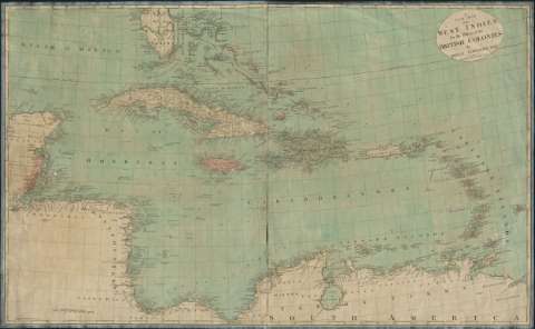
New Map of the West Indies : For the History of the British Colonies (1793)
Maps, plans and nautical charts
New Map of the West Indies : For the History of the British Colonies (1793)
 Disponible Holdings
 Section: Maps, plans and nautical charts
Uniform title: Caribe (Mar). Cartas náuticas. 1793. 1:3700000
Title: New Map of the West Indies : For the History of the British Colonies / By Bryan Edwards
Material or type of resouce Area: Scale [ca. 1:3.700.000]. 180 English Miles 69 1/2 to a Degree [= 8,7 cm]
Publication: London : I. Stockdale, Piccadilly, 1793
Physical description: 1 carta náutica : col. ; 67 x 112 cm
Content type: Imagen cartográfica
Media type: computadora
Carrier type: recurso en línea
Notes: Longitud respecto del meridiano de Londres
Relieve representado por sombreado en línea de costa y montes de perfil
Indica veriles y bajos. Márgenes graduados
Señala la dirección de las corrientes marinas mediante flechas
Materia / lugar / evento: Cartas náuticas
Antillas
Caribe (Mar)
Other authors: Stockdale, John, 1750-1814
Edwards, Bryan
UDC: 261.4 Caribe
Type of publication:
Maps
Rights:
Préstamo:
Disponible
