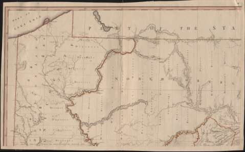
A Map of the State of Pennsylvania


Section: Maps, plans and nautical charts
Uniform title: Pensilvania. Mapas generales. 1792. 1:330.000
Title: A Map of the State of Pennsylvania / by Reading Howell
Material or type of resouce Area: Escala [ca. 1:330.000]. 40 miles [= 19,5 cm] ( (O 5º30'-E 0º30'/N 42º15'-N 39º30')
Publication: London : Published for the Author, & Sold by James Phillips, George Yard, Lombard Street, 1792
Physical description: 1 mapa en 4 h. : grab., col. ; h. de 47 x 80 cm
Content type: Imagen cartográfica
Media type: computadora
Carrier type: recurso en línea
Notes: Nota explicativa de los límites de Pensilvania con sus condados y distritos realizada por Samuel Caldwell
Dedicatoria a Thomas Misslin orlada en guirnalda con un navío
Orientado con lis inscrita en rosa de 8 vientos
Meridiano de origen: Filadelfia. Red geográfica de 30' en 30'
Relieve por normales
Red hidrográfica y de caminos
Lavado en rojo, amarillo, verde y azul
Título orlado con motivos vegetales y utensilios agrícolas
Inserta: clave de signos convencionales para indicar los límites de municipios, distritos, localización de molinos, hornos, minerales... etc
Materia / lugar / evento: Mapas generales
Pensilvania
Estados Unidos
Other authors: Howell, Reading, 1743-1827
UDC: (748)
Type of publication:
 Maps
Maps
Rights:
Préstamo:
 Disponible
