Map of the Country round Cadiz : Comprehending St. Lucar...


 Maps, plans and nautical charts
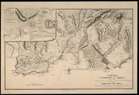
Map of the Country round Cadiz : Comprehending St. Lucar de Barrameda, Xerez, Medina, Conil, Chiclana ... (May 20th. 1811)
Maps, plans and nautical charts
Map of the Country round Cadiz : Comprehending St. Lucar de Barrameda, Xerez, Medina, Conil, Chiclana ... (May 20th. 1811)
 Disponible Holdings
 Section: Maps, plans and nautical charts
Uniform title: Cádiz (Provincia). Mapas generales (1811). 1:130.000
Title: Map of the Country round Cadiz : Comprehending St. Lucar de Barrameda, Xerez, Medina, Conil, Chiclana ... / Spanish Map of José Cardona
Edición: Republished/W. Faden
Material or type of resouce Area: Escala [ca. 1:130.000]. 5 Britisch Statute Miles [= 6,4 cm]
Publication: [London] : W. Faden Geographer to His Majesty and to His Royal Highnefs the Prince Regent, Charing Crofs, May 20th. 1811
Physical description: 1 mapa : montado sobre tela ; 32,5 x 51,3 cm en h. de 37,5 x 54,2 cm
Content type: Imagen cartográfica
Media type: computadora
Carrier type: recurso en línea
Notes: Orientado con lis en cuadrante
Relieve representado por normales y por sombreado
Indica veriles y bajos
Señala las fortificaciones, los cultivos y las masas forestales
Inserta: Sketch of the Action near the Hill of Barrosa on the 5th. of March 1811
Materia / lugar / evento: Mapas generales
Núcleos de población
Cultivos
Vegetación
Guerras de independencia
1811
Sanlúcar de Barrameda
Jerez de la Frontera
Chiclana de la Frontera
Cádiz (Provincia)
Andalucía
España
España - Historia - 1808-1814 (Guerra de la Independencia)
Other authors: Cardona, José
Faden, William, 1749-1836
UDC: (460.355)
Type of publication:
Maps
Rights:
Préstamo:
Disponible
