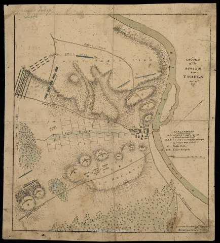
Ground of the Action near Tudela Novr. 23 d. 1808


 Disponible Holdings
 Section: Maps, plans and nautical charts
Title: Ground of the Action near Tudela Novr. 23 d. 1808 / Quarter Master Genls. Office. Horse Guards. Janry. 5th. 1809
Material or type of resouce Area: Escala [ca. 1:14.300]. 800 yardas [=5,1 cm]
Publication: [United Kingdom : [Editor no identificado]], 1809
Physical description: 1 mapa : col., montado sobre tela ; 36 x 32 cm
Content type: Imagen cartográfica
Media type: computadora
Carrier type: recurso en línea
Notes: Orientado con media flecha
Relieve representado a trazos
Relación de los ataques efectuados por las tropas francesas y españolas, así como los avances, lugares y líneas de tiro que establecieron, todo ello indicado por clave alfabética
Materia / lugar / evento: Estrategia militar
Operaciones bélicas
Batallas
Guerras de independencia
1808
Tudela
Navarra (Comunidad Autónoma)
España
España - Historia - 1808-1814 (Guerra de la Independencia)
Other authors: Gran Bretaña. Army. Royal Regiment of Horse. Royal Regiment of Horse. Quarter Masr. Genl. Office
UDC: 912:355.43:355.4(465.111.5)"1808"
465.111.5 Tudela, Término Municipal
Type of publication:
 Maps
Maps
Rights:
Préstamo:
Disponible
