
 Cartopraphy of Cuba
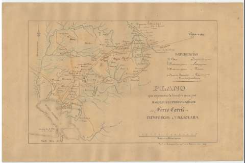
Plano que representa la linea trazada por D. Alejo...


 Available Holdings
 Maps, plans and nautical charts
Plano que representa la linea trazada por D. Alejo Helvecio Lanier del Ferro Carril de Cienfuegos á Villaclara (año 1847)
Section: Maps, plans and nautical charts
Uniform title: Cienfuegos (Cuba). Líneas ferroviarias. 1:211756 (1847)
Title: Plano que representa la linea trazada por D. Alejo Helvecio Lanier del Ferro Carril de Cienfuegos á Villaclara / Copdo. en la comandcia. de ingos. de la Habana
Material or type of resouce Area: Escala [ca. 1:211756], 15 Millas inglesas [= 11'4 cm]
Publication: año 1847
Physical description: 1 mapa : ms., col. ; 31.5 x 48.0 cm
Content type: Imagen cartográfica
Media type: computadora
Carrier type: recurso en línea
Notes: Comprende la parte oriental de la provincia de Cienfuegos, entre la bahía de Jagua y las poblaciones de Cartagena y Fernando de Camarones, y la parte central de la de Villa Clara, entre las ciudades de Esperanza, Santa Clara y San Juan de los YerasOrientado con lisRelieve por sombreadoSeñala la dirección de la corriente de los principales ríos representados en este área geográficaTabla de signos convencionales para indicar núcleos de población de distinta categoría, tipos de haciendas, aguas termales, camino real y la línea del ferrocarrilLavado en azul, carmín, siena y gris
Subject / place /event: Líneas ferroviarias Mapas generales Las Villas - Mapas Cienfuegos - Mapas Santa Clara (Cuba) - Mapas
Genre / form: Mapas generales
UDC: (729.14)
Type of publication:
Maps
Rights:
Loan:  No permitido
