
 Cartopraphy of Cuba
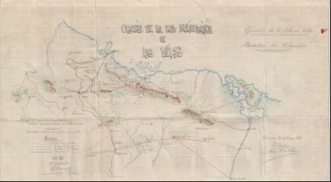
Croquis de la red heliográfica de Las Villas


 Available Holdings
Section: Maps, plans and nautical charts
Uniform title: Villa Clara (Cuba). Comunicaciones. 1:300000 (1897)
Title: Croquis de la red heliográfica de Las Villas / Ejército de la Isla de Cuba. Batallon de Telegrafos ; El Capitán Luis G. Estefany
Material or type of resouce Area: Escala 1:300000
Publication: Morón, 11 de Mayo 1897
Physical description: 1 mapa : ms., col. ; 37,9 x 66,0 cm
Content type: Imagen cartográfica
Media type: computadora
Carrier type: recurso en línea
Notes: Comprende la parte oriental de la provincia de Villa Clara entre Santa Clara y Manicaragua, la septentrional de la de Sancti Spíritus entre Sancti Spíritus y Jatibónico, y la parte occidental de la provincia de Ciego de Avila entre Morón y Ciego de Avila"Conforme": el Coronel ChanelManuscrito firmado y rubricado por el autorEscala también dada en forma gráfica de 30 kilómetrosRelieve representado por curvas de nivelManuscrito a plumilla en tinta negra y coloreado a la acuarela en varios coloresTabla de signos convencionales para indicar la red heliográfica, la línea telefónica, el límite provincial y la línea del ferrocarril
Subject / place /event: Comunicaciones Topónimos antiguos Líneas ferroviarias Líneas telefónicas Sancti Spíritus (Provincia) Ciego de Ávila Villa Clara Cuba
UDC: (729.14 Santa Clara)
Type of publication:
 Maps
Rights:
Loan:  No permitido
