
 Cartopraphy of Cuba
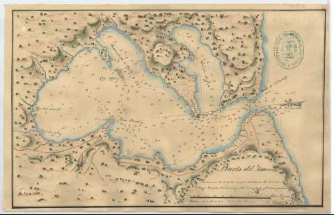
Puerto del Mariel


 Available Holdings
Section: Maps, plans and nautical charts
Title: Puerto del Mariel / Es copia del Portulano Carrillo
Material or type of resouce Area: Escala [ca. 1:22594], 2000 varas castellanas [= 7'4 cm]
Publication: Habana, 16 de Sbre. de 1827
Physical description: 1 carta náutica : ms., col., montado sobre tela ; 19.1 x 30.2 cm
Content type: Imagen cartográfica
Media type: computadora
Carrier type: recurso en línea
Notes: Firmado y rubricado por el autorOrientado con media lisRelieve por sombreadoIndica sondas batimétricas, veriles y fondeaderosClave hidrográfica para determinar la calidad del fondoToponimia costera de los principales accidentes geográficos y núcleos de población más significativosLavado en verde, carmín y azultes del área representadaRubricado con la firma ilegible del autor del original, y por la del autor de la copia
Other authors: Carrillo de Albornoz, Mariano, 1784-1860
UDC: 729.12-16
Type of publication:
 Maps
Rights:
Loan:  No permitido
