Puerto Padre


Section: Maps, plans and nautical charts
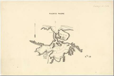
Title: Puerto Padre
Material or type of resouce Area: Escala [ca. 1:82000]
Physical description: 1 mapa : ms. ; 35'6 x 53'3 cm
Content type: Imagen cartográfica
Media type: computadora
Carrier type: recurso en línea
Notes: Plano de la bahía de Puerto Padre, en la costa septentrional de la provincia de Oriente, en la que se señalan sondas batimétricas, veriles, calidad del fondo, y la línea de derrota a seguir para alcanzar su fondeadero
Fecha tomada del "Catálogo de Mapas y Planos: Cuba" del SGE, 1974
Escala hallada a partir de la mención de la distancia en metros del radio de acción de la fortificación que defiende la bahía. Orientado con flecha
Dibujado a plumilla
En el ángulo inferior derecho: "N° 10"
Posiblemente pertenece a una colección de aproximadamente 35 mapas de los que sólo constan trece, de bahías y puertos de Cuba
Reproducción digital. Centro Geográfico del Ejército, 2009
Materia / lugar / evento: Edificios militares
Cartas náuticas
Fortificaciones
Derroteros
S.XIX
Oriente (Cuba)
UDC: (729.16 Puerto Padre)
Type of publication:
 Maps
Maps
Rights:
Préstamo:
 Disponible
