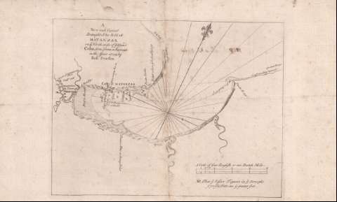
New and Correct Draught of the Bay of Matanzas on the...


 Maps, plans and nautical charts
New and Correct Draught of the Bay of Matanzas on the North side of the Island Cuba (1729?)
Maps, plans and nautical charts
New and Correct Draught of the Bay of Matanzas on the North side of the Island Cuba (1729?)
 Disponible Holdings
 Section: Maps, plans and nautical charts
Uniform title: Matanzas (Cuba) (Bahía). Cartas náuticas (1729?). 1:80515
Title: New and Correct Draught of the Bay of Matanzas on the North side of the Island Cuba / done from a Survey in the Year 1729, by Robt. Pearson
Material or type of resouce Area: Escala [ca. 1:80515], four English or one Dutch Mile [= 9,2 cm]
Publication: [United Kingdom : [Editor no identificado], 1729?]
Physical description: 1 carta náutica ; 23 x 31 cm
Content type: Imagen cartográfica
Media type: computadora
Carrier type: recurso en línea
Notes: Título y autor tomados del verso documento
Orientado con lis en nudo de 32 rumbos
Relieve de perfil
Indica veriles, bajos, bancos, fondeaderos y sondas batimétricas
Señala la duración de las mareas
Indica la toponimia de los accidentes geográficos de la costa
Materia / lugar / evento: Cartas náuticas
Batimetría
Bahías
Mareas
Accidentes geográficos
Toponimia
Siglo XVIII
Matanzas (Bahía)
Other authors: Pearson, Robert
UDC: 729.13
Type of publication:
Maps
Rights:
Préstamo:
Disponible
