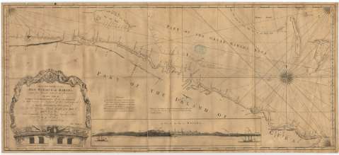
An Accurate Draught of the Old Straits of Bahama : made...
Section: Maps, plans and nautical charts
Uniform title: CUBA. NE. Cartas náuticas. 1:370370 (1762?)
Title: An Accurate Draught of the Old Straits of Bahama : made from the Remarks taken in the Year 1762 / by leave from the Lords Commissioners of the Admiralty, in order to render the Navigator of those ports more safe is humbly Dedicated by Permission to Sr. George Pocock Knight of the Bath Admiral of the Blue, an Comander in Chief of His Majesty's Fleet at the Havana, by his most Obedient Servant Robt. Bishop engrav'd by Enmanuel Bowen
Material or type of resouce Area: Escala [ca. 1:370370]
Publication: 1762?]
Physical description: 1 carta náutica ; ms., montado sobre tela ; 43 x 96 cm
Content type: Imagen cartográfica
Media type: computadora
Carrier type: recurso en línea
Notes: Comprende la isla de Cuba, hasta la mitad de las provincias de las Tunas y Gramma
Escala hallada por comparación con otros documentos de características similares. Coordendas referidas al meridiano de Washington (O 09°00'-E 00°15'/N 24°00'-N 20°00'). Orientado con lis en rosa de 24 vientos
Tabla de signos convencionales para señalar los principales puntos del mapa
Título y autor enmarcados en cartela decorada con motivos marinos y navales
Figura un escudo
Sello del Depósito General Topográfico de Ingenieros
Inserta: "Vista de la ciudad de la Habana". Escala indeterminada. Decorada con motivos marinos
Materia / lugar / evento: Cartas náuticas
Perspectivas de ciudades
Dibujos
Heráldica
Siglo XVIII
La Habana
Cuba
Other authors: Bishop, Robert, fl. 1761-1796
Bowen, Emanuel, m. 1767
UDC: 729.1-18
Type of publication:
![]() Maps
Maps
Préstamo:
![]() Disponible
Disponible


