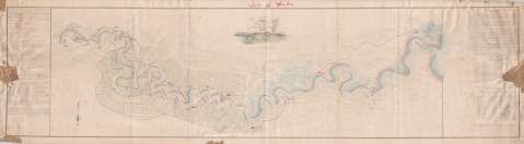
Plano del Rio Cauto y sus inmediacionmes


 Disponible Holdings
 Section: Maps, plans and nautical charts
Uniform title: Cauto (Cuba) (Río). Mapas generales (1848). 1:27500
Title: Plano del Rio Cauto y sus inmediacionmes / copiado por Alejdro. Jaegerschmiv ingeniero civil ; mandado sacar y dedicado a la Real Sociedad Económica de la Habana por el Sñr. Dn. Miguel Rodriguez-Ferrer
Material or type of resouce Area: Escala [ca. 1:27.500]. 1 legua provincial de 5000 varas castellanas [= 15'2 cm]
Publication: 1848
Physical description: 1 mapa : ms., col. ; 43 x 169 cm
Content type: Imagen cartográfica
Media type: computadora
Carrier type: recurso en línea
Notes: Manuscrito a plumilla en tinta negra y coloreado a la acuarela en azul, rojo y verde
Orientado con flecha y lis
Señala la distribución de las tierras mostrando las de cultivo, la dirección de la corriente, las distancias entre distintos puntos y particularidades del río Cauto
Relación de los lugares más destacados de la zona, indicados por clave numérica
Amplia leyenda explicativa en la que se señalan los motivos por los que se ha realizado el mapa, descripción del río desde que se descubrió, enumeración de los buques que intervinieron en la expedición para la realización de este mapa y los productos que se recogen en las orillas del río y las exportaciones
Materia / lugar / evento: Mapas generales
Ríos
Agricultura
S.XIX
Cuba
Other authors: Rodríguez Ferrer, Miguel, 1815-1889
UDC: 729.1
Type of publication:
 Maps
Maps
Rights:
Préstamo:
Disponible
