Plan of the City and Suburbs of Dublin, A : With the...


 Mapas, planos y cartas náuticas
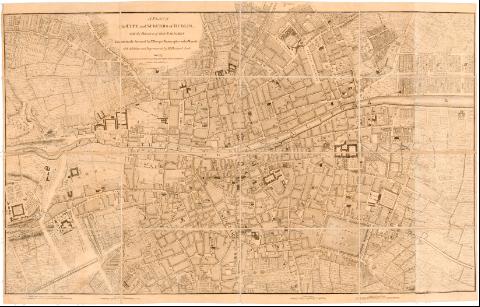
Plan of the City and Suburbs of Dublin, A : With the Division of Their Parisnes Geometrically suveryed (1773)
Mapas, planos y cartas náuticas
Plan of the City and Suburbs of Dublin, A : With the Division of Their Parisnes Geometrically suveryed (1773)
 Disponible Ejemplares
 Sección: Mapas, planos y cartas náuticas
Título uniforme: DUBLIN (Irlanda) (Leinster). Planos de población. 1:5000 (1773)
Título: Plan of the City and Suburbs of Dublin, A : With the Division of Their Parisnes Geometrically suveryed / by J. Rocque topographer to his Mapsty wifer additions and Imarovements by Mr. Bernard Scole
Área de datos: Escala [ca. 1:5000], 200 french Toises [= 8 cm]
Publicación: London : Printed for Robt. Sayer. Map Printseller N 53 in Fleet street, 1773
Descripción física: 1 plano ; 52,5x62 cm
Notas: Escalas graficas de 2 Furlong or 1/4 of a Mile equal to 440 yards [= 8,5 cm], 50 Iris Perche [= 7 cm] y 60 English Perche [= 6 cm] y 200 French Toise [= 7,5 cm]
Indica masas forestales y campos de cultivo
Entelado en 16 cuarterones
Materia / lugar / evento: Planos de población
1773
Otros autores: Rocque, John
Scalé, Bernard
Sayer, Robert, 1725-1794
CDU: 912:314(417 Dublin)'1773'(084.3)
417 Dublin
Tipo de publicación:
Mapas
Derechos:
Préstamo:
Disponible
