Map showing Recent acquisitions to the Geography of the...


 Mapas, planos y cartas náuticas
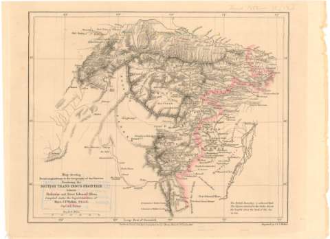
Map showing Recent acquisitions to the Geography of the Districts Bordering the British Trans - Indus frontier... (1863)
Mapas, planos y cartas náuticas
Map showing Recent acquisitions to the Geography of the Districts Bordering the British Trans - Indus frontier... (1863)
 Disponible Ejemplares
 Sección: Mapas, planos y cartas náuticas
Título uniforme: PAKISTAN. Mapas generales. 1:2000000 (1863)
Título: Map showing Recent acquisitions to the Geography of the Districts Bordering the British Trans - Indus frontier between Peshawur and Dera Ishmael Khan / compiled under the Superintendence of Major J.T. Walker... ; Engraced by J. & C. Walker
Área de datos: Escala [ca. 1:2000000], 60 English Miles [= 5 cm] ; [proyec. cónica] (E67°30'-E72°00'/N34°10'-N31°30')
Publicación: London : Pubd. for the Journal of the Royal Geographical Socv. by J. Murray, Albemarle Strt., 1863
Descripción física: 1 mapa : col. ; 19'3x23'8 cm en h. de 22x29'8 cm
Tipo de contenido: Imagen cartográfica
Tipo de medio: computadora
Tipo de soporte: recurso en línea
Notas: Comprende el norte de Pakistán y el sureste de Afganistán
Relieve representado por normales
Indica la frontera entre Pakistán y Afganistán en carmín
Materia / lugar / evento: Mapas generales
Fronteras
1863
Afganistán
Otros autores: Walker, James Thomas
Murray, John
J. & C. Walker
CDU: 912:341.222(549-17)'1868'
(581-12)
Tipo de publicación:
Mapas
Derechos:
Préstamo:
Disponible
