A Map Exhibiting all the Neuw Discoveries in the Interior...


 Mapas, planos y cartas náuticas
A Map Exhibiting all the Neuw Discoveries in the Interior Parts of North America : Incribed by Permission to the... (1802)
Mapas, planos y cartas náuticas
A Map Exhibiting all the Neuw Discoveries in the Interior Parts of North America : Incribed by Permission to the... (1802)
 Disponible Ejemplares
 Sección: Mapas, planos y cartas náuticas
Título uniforme: CANADA. Mapas generales (1802). 1:3700000
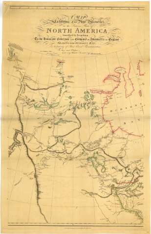
Título: A Map Exhibiting all the Neuw Discoveries in the Interior Parts of North America : Incribed by Permission to the honorable Governor and Company of Adbentures of England Trading into Hudsons Bay in testimony of their liberal Communications / To their most Obedient and very Humble Servant A arrowsmith
Edición: Additions to 1802
Área de datos: Escala [ca. 1:3700000 ; proyección cónica simple] (O 145°--O 30°/N 70°--N 35°)
Publicación: London : Published by A. Arrowsmith n° 24 Rathbone place, 1802
Descripción física: 1 map. en 2 h. : col. ; 91 x 110 cm en h. de 100 x 66 o menor
Notas: Comprende desde las Montañas Rocosas hasta la costa oriental de Cánada incluyendo parte del norte de Estados Unidos, destacándose la red hidrográfica
Fecha de publicación de la edición original 1 de Enero de 1795
Escala hallada a partir de cinco grados de latitud [= 15 cm]. Red geográfica de 5° en 5°
Orografía representada por normales. Indica sondas batimétricas
Constan varias notas explicativas y comentarios. Se señalan las corrientes marinas en la Bahía de Hudson
Lavado en rosa y verde
Falta una Hoja de las tres que formarían el mapa completo
Materia / lugar / evento: Mapas generales
Hidrografía
1802
Otros autores: Arrowsmith, Aaron, 1750-1823
CDU: 912:551.48(71)"1802"
71
Tipo de publicación:
Mapas
Derechos:
Préstamo:
Disponible
