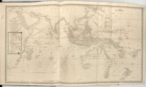
A Chart of The Indian Ocean : Improved from The Chart or...


 Mapas, planos y cartas náuticas
A Chart of The Indian Ocean : Improved from The Chart or M D'Apres de Mannevillette with The Addition of a Part of... (1803)
Mapas, planos y cartas náuticas
A Chart of The Indian Ocean : Improved from The Chart or M D'Apres de Mannevillette with The Addition of a Part of... (1803)
 Disponible Ejemplares
 Sección: Mapas, planos y cartas náuticas
Título uniforme: INDICO (Océano). Cartas náuticas (1803). 1:3000000
Título: A Chart of The Indian Ocean : Improved from The Chart or M D'Apres de Mannevillette with The Addition of a Part of The Pacif Ocean as well as of The Original Tracks of The Principal Discoverers or The Navigators to India and China and in which it has been attempted to give a Chronological Indication of The succesive Discoveries / By. L.S. De La Rochette
Área de datos: Escala [Ca. 1:3.000.000] ; [proyec. Mercator]
Publicación: London : Published by W. Faden Geographer to The King and to H.R.H The Principe of Wales, 1803
Descripción física: 1 carta nautica ; 61x113 cm en h. de 66x119 cm, pleg en 48'5x65 cm
Tipo de contenido: Imagen cartográfica
Tipo de medio: computadora
Tipo de soporte: recurso en línea
Notas: Presenta además 2 mapas de 'North - East Monsoon' y 'South west Monsoon'
En : 'Charts Red Sea'
Escala grafica hallada a partir de un grado de latitud [= 3'5 cm]. Coordenadas referidas al meridiano de Londes (E15°50'-E190°25'/N35°10'-S45°25'). Red geografica de 5° en 5°. Orientado con lis en nudo de rumbos
Relieve representado por sondas batimetricas
Indica veriles, bajos y fondeaderos
En el margen inferior 'Approved by The Chart Comittee of The Admiralty'
En : Charts Red Sea
Materia / lugar / evento: Cartas náuticas
Derroteros
1803
Otros autores: La Rochette, Louis Stanislas D'Arcy de
Faden, William, 1749-1836
CDU: 912:[551.46:527.6](267)'1803'
267
Tipo de publicación:
Mapas
Derechos:
Préstamo:
Disponible
