Map of the world illustrating the principal features of...


 Mapas, planos y cartas náuticas
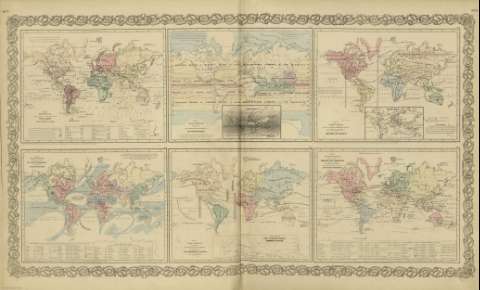
Map of the world illustrating the principal features of the land and the co - tidal lines (1872)
- Colton, G. Woolworth, 1827-1901
Mapas, planos y cartas náuticas
Map of the world illustrating the principal features of the land and the co - tidal lines (1872)
- Colton, G. Woolworth, 1827-1901
 Disponible Ejemplares
 Sección: Mapas, planos y cartas náuticas
Título: Map of the world illustrating the principal features of the land and the co - tidal lines / [drawn by George Woolworth Colton]
Autor: Colton, G. Woolworth, 1827-1901
Área de datos: Escala indeterminada (O 180º--E 180º /N 80º--S 70º)
Publicación: New York : published by G.W. and C.B. Colton & Co., [1872]
Descripción física: 1 mapa : col. ; 17 x 22 cm, en h. de 44 x 36 cm
Tipo de contenido: Imagen cartográfica
Tipo de medio: computadora
Tipo de soporte: recurso en línea
Notas: Incluye leyenda de signos utilizados.
Inserta: List or table lands or plateurs ; Plains or Lowlands.
Con: Map of the world illustrating the principal features of meteorology ; Map of the world showing the geographical distribution & rauge of the principal members of the animal kingdom ; Map of the world showing the principal ocean currents & boundaries of river systems ; Map of the world showing the distribution and limits of cultivation of the principal plants ; Map of the world illustrating the productive industry of various countries & exhibiting the principal features of commerce and navigation.
Copia digital. España : Ministerio de Cultura y Deporte. Subdirección General de Coordinación Bibliotecaria, 2010
Registros relacionados: En: Colton's General Atlas : containing one hundred and eighty steel plate maps and plans, on one hundred and nineteen imperial folio sheets. - New York : published by G.W. and C.B. Colton & Co. n 172 William St., [1872]. - Nº 7 - 8
Materia / lugar / evento: Declinación magnética
Montañas
Fitogeografía
Mareas
Mundo - Mapas
Otros autores: G.W. & C.B. Colton & Co
Títulos secundarios: Mundo. Mapas físicos (1872)
CDU: 912:911.2]:[528.02+551.43+581.9+551.466](100)'1872'
100
Tipo de publicación:
Mapas
Derechos:
