South End of Green Bay the Islands at the Entrance...


 Mapas, planos y cartas náuticas
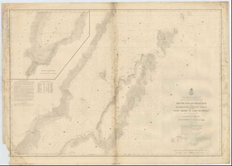
South End of Green Bay the Islands at the Entrance Thereof and part of West Shore of Lake Michigan (1864-1870?)
Mapas, planos y cartas náuticas
South End of Green Bay the Islands at the Entrance Thereof and part of West Shore of Lake Michigan (1864-1870?)
 Disponible Ejemplares
 Sección: Mapas, planos y cartas náuticas
Título uniforme: GREEN BAY (Estados Unidos) (Bahía). Cartas náuticas. 1864-1870? (1863-1864). 1:120000
Título: South End of Green Bay the Islands at the Entrance Thereof and part of West Shore of Lake Michigan / Projected from Trigonometrical Surveys executed under the orders of Col. J.D. Graham U.S. Engrs. in 1863 and Col. W.F. Raynolds A.D.C. and Maj. of Engrs. in 1864
Área de datos: Escala 1:120000 (O 88°00'--O 86°30'/N 45°31'--N 44°46')
Publicación: [Washington] : Bureau of Engineers of the War Department, [1864-1870?]
Descripción física: 1 carta náutica ; 70 x 100 cm
Tipo de contenido: Imagen cartográfica
Tipo de medio: computadora
Tipo de soporte: recurso en línea
Serie: (Survey of the Northern and North Western Lakes)
Notas: Figura la firma de conformidad del Capitan de Ingenieros F.H. Tamgaliac
Escala también dada en formas gráficas de 20000 yardas y 10 millas legales
Indica sondas batimétricas y veriles
Clave hidrográfica para determinar la calidad del fondo
Tabla que informa de los faros existentes en la bahía
En nota, se señala todos aquellos trabajos tenidos en cuenta para la elaboración del presente documento
En otra nota explican las líneas de derrota a seguir para arribar a la bahía
Inserta: "Head of Green Bay and entrance to Fox River". Escala [ca. 1:30000], hallada por comparación. Orientado con nudo de veintidos rumbos la que señala además la variación magnética observada
Materia / lugar / evento: Cartas náuticas
Batimetría
Bahías
1864
Otros autores: Graham, James Duncan
Raynolds, W. F
Estados Unidos. War Department. Engineer Bureau
CDU: 775-18
Tipo de publicación:
Mapas
Derechos:
Préstamo:
Disponible
