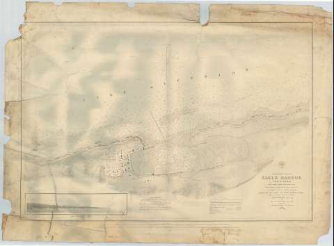
Preliminary Chart of Eagle Harbor : Lake Superior


 Disponible Ejemplares
 Sección: Mapas, planos y cartas náuticas
Título uniforme: EAGLE HARBOR (Estados Unidos) (Michigan) (Puerto). Cartas náuticas. 1858 (1855). 1:5000
Título: Preliminary Chart of Eagle Harbor : Lake Superior / From surveys under the direction of the topographical Bureau of the War Department..., Surveyed and drawn under the direction of Captain J.N. Macomb Topl. Engrs. by Lieut W.F. Raynolds Topl. Engrs. Assisted by J.U. Mueller D.F. Henry and J. Wallace. 1855 ; Drawn for Engraving by Lt. Om. Poe, Topl. Engrs. and H. Gillman ; Engraved by W.H. Dougal
Área de datos: Escala 1:5000
Publicación: [Washington] : Bureau of Topographical Engineers of the War Department, [1858?]
Descripción física: 1 carta náutica ; 51 x 74 cm
Tipo de contenido: Imagen cartográfica
Tipo de medio: computadora
Tipo de soporte: recurso en línea
Serie: (Survey of the Northern and North Western Lakes)
Notas: Escala también dada en formas gráficas de 1 milla legal y 1 milla náutica. Orientado con nudo de treintaidos rumbos, en la que señala además la variación magnética observada
Fecha tomada del sello que figura en el documento
Relieve por normales
Indica sondas batimétricas y veriles, así como los distintas líneas de derrota aseguir para arribar al puerto
Clave hidrográfica para determinar la calidad del fondo
En nota se explican las diferentes derrotas a seguir para arribar al puerto
Otra nota que informa de las coordenadas de situación de Eagle Harbor respecto al meridiano de Greenwich
Inserta una perspectiva de costa
Materia / lugar / evento: Cartas náuticas
Batimetría
Perspectivas de costas
1855
1858
Otros autores: Raynolds, W. F
Dougal, W. H
Mueller, J. U
Henry, D. F
Wallace, J
Macomb, J. N
Poe, O. M
Gillman, Henry
Estados Unidos. War Department. Engineer Bureau
CDU: 774-16
Tipo de publicación:
 Mapas
Mapas
Derechos:
Préstamo:
Disponible
