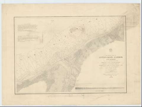
Preliminary Chart of Ontonagon Harbour : Lake Superior


 Disponible Ejemplares
 Sección: Mapas, planos y cartas náuticas
Título uniforme: ONTONAGON (Estados Unidos) (Puerto). Cartas náuticas (1859). 1:16000
Título: Preliminary Chart of Ontonagon Harbour : Lake Superior / from surveys under the direction of the Topographical bureau of the war department in obedience to Acts of congress requiring the survey of the north and north wertern Lakes surveyed and drawn under the direction of Captains J.N. Macomb Topl. Engrs. by Lieut. W.F. Raynolds Topl. Engrs. assisted by J.U. Mueller, D.F. Henry and J. Wallace ; reduced for publication under the direction of Captain G.G. Meade Topl. Engrs. 1859 ; Drawn for engraving by Joshua Barney ; engraved by W.H. Dougal
Área de datos: Escala 1:16000
Publicación: [Washington] : The Bureau of Engineers of the war Department, 1859
Descripción física: 1 carta náutica ; 37 x 50 cm
Tipo de contenido: Imagen cartográfica
Tipo de medio: computadora
Tipo de soporte: recurso en línea
Notas: Escala también dada en formas gráficas de 2 millas estatutarias y 2 millas náuticas. Orientado con nudo de rumbos, en el que se señala además la variación magnética observada
Relieve por sombreado
Indica sondas batimétricas y bajos
Figura el sello impreso de: "Survey of the Lakes 1859"
Inserta una perspectiva del puerto, dibujado por J. Mueller en 1855
Materia / lugar / evento: Cartas náuticas
Perspectivas de costas
1855
1859
Otros autores: Macomb, J. N
Raynolds, W. F
Mueller, J. U
Henry, D. F
Wallace, J
Meade, George G
Barney, Joshua
Dougal, W. H
Estados Unidos. War Department. Engineer Bureau
CDU: 774-16
Tipo de publicación:
 Mapas
Mapas
Derechos:
Préstamo:
Disponible
