Upper Potomac from Mccoy's Ferry to Conrad's Ferry and...


 Mapas, planos y cartas náuticas
Upper Potomac from Mccoy's Ferry to Conrad's Ferry and adjacent portions of Maryland and Virginia showing the... (189-?)
Mapas, planos y cartas náuticas
Upper Potomac from Mccoy's Ferry to Conrad's Ferry and adjacent portions of Maryland and Virginia showing the... (189-?)
 Disponible Ejemplares
 Sección: Mapas, planos y cartas náuticas
Título uniforme: ESTADOS UNIDOS. SO. Maniobras de campaña. 189. 1:131912 (1865)
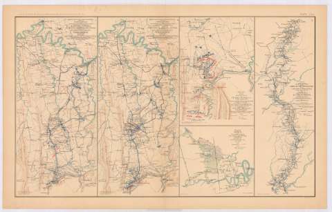
Título: Upper Potomac from Mccoy's Ferry to Conrad's Ferry and adjacent portions of Maryland and Virginia showing the operations of the Army of the Shenandoah. Commanded by Maj. Gen. P.H. Sheridadn, U.S.A. Map. N 5 / Engineer Office Military Division of the Gulf ; Drawn and lithographed under direction of BVT. Maj. Gen. G.L. Gillespie, U.S.A. Chief Engineer Mil. Div. of the Gulf, October, 1865
Área de datos: Escala [ca. 1:131912], 5 miles [= 6'1 cm]
Publicación: Washington : Government Printing Office, [189-?] (N.Y. [Nueva York] : Julius Bien & co.)
Descripción física: 1 mapa : col. ; 41x19 cm, en h. de 47x75 cm
Tipo de contenido: Imagen cartográfica
Tipo de medio: computadora
Tipo de soporte: recurso en línea
Notas: En : Atlas to accompany the Official Records of the Union and Confederate Armies 1861-1865. - Plate LXIX, n 1
Relieve : lineas perpendiculares normales
Mapa que acompaña al informe del 'Maj. Gen. P.H. Sheridan'
Figura leyenda de autoridades
Orientado con flecha
Figura en margen inferior : Series 1. Vol. XLIII
Representadas mediante diferente color las posiciones del ejército federal y confederado
En : Atlas to accompany the Official Records of the Union and Confederate Armies 1861-1865
Materia / lugar / evento: Guerra civil
Operaciones bélicas
Maniobras de campaña
Mapas militares
Redes de transporte
1865
Maryland
Virginia
Estados Unidos
CDU: 912:355.4]:355.52(752+755)'1865'
912:355(752+755)'1865'
752
755
Tipo de publicación:
Mapas
Derechos:
Préstamo:
Disponible
