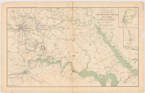
Part of the map of the military department of...
Sección: Mapas, planos y cartas náuticas
Título uniforme: VIRGINIA (Estados Unidos) (Estado). Operaciones bélicas. 1892. 1:146303 (1861-1862)
Título: Part of the map of the military department of Southeastern Virginia and Fort Monroe showing the aproaches to Richmond and Petersburg / Compiled in the Bureau of topographical Engineers of the War Department, 1861, with additions and corrections from the map of the siege of Forktown and the compaign maps of the Army of the Potomac, compiled by Capt. H.L. Abbot Corps topog. Engrs., 1862
Área de datos: Escala [ca. 1:146303], 5 miles [= 5'5 cm]
Publicación: Washington : Government Printing Office, [189-?] (N.Y. [Nueva York] : Julius Bien & co.)
Descripción física: 1 mapa : col. , 47x75 cm ; 47 x 65 cm
Tipo de contenido: Imagen cartográfica
Tipo de medio: computadora
Tipo de soporte: recurso en línea
Notas: En : Atlas to accompany the Official Records of the Union and Confederate Armies 1861 - 1865. - Plate XVII, N 1
Relieve : lineas perpendiculares normales
Orientado con flor de lis
Mapa que acompaña al informe del Maj. Gen. C.B. McClellan
Figura en margen inferior : Series 1. Vol XI. Part 1. Page 5
En : Atlas to accompany the Official Records of the Union and Confederate Armies 1861 - 1865
Materia / lugar / evento: Guerra civil
Operaciones bélicas
Estrategia
Redes de transporte
1862
Estados Unidos
Otros autores: Estados Unidos. War Department. Engineer Bureau
Government Printing Office (Estados Unidos)
CDU: 912:355.4]:[355.4+355.43]'1861/1862'(755)
755
Tipo de publicación:
![]() Mapas
Mapas
Préstamo:
![]() Disponible
Disponible


