A chart of the currents in the Indian Sea : during the...


 Mapas, planos y cartas náuticas
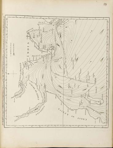
A chart of the currents in the Indian Sea : during the south West Monsoon to the Northward of the Line (1778)
Mapas, planos y cartas náuticas
A chart of the currents in the Indian Sea : during the south West Monsoon to the Northward of the Line (1778)
 Disponible Ejemplares
 Sección: Mapas, planos y cartas náuticas
Título uniforme: INDICO (Océano). Mapas físicos. 1:18000000 (1778)
Título: A chart of the currents in the Indian Sea : during the south West Monsoon to the Northward of the Line [Mapa] / by Msr Le Vicomte Grenier ; Printed for Robt. Sayer an Jn° Bennett
Área de datos: Escala [ca. 1:18000000]
Publicación: London : Printed for Robert Sayer and Jno. Bennett, 1778
Descripción física: 1 map. ; 43 x 47 cm
Notas: En : "The East India Pilot or oriental Navigator", part. I, map. n° 29
Graduado, longitud tomada del meridiano de Londres. Escala hallada a partir de un grado de latitud [= 0,7 cm]
Sombreado el litoral
Aparecen localizadas las principales ciudades costeras
Representa la dirección de las corrientes y de los vientos en el océano Indico
Otros autores: Grenier, Jacques-Raymond
Bennett, John
Sayer, Robert, 1725-1794
CDU: 912:551.465]:551.55(267)"17"
267
Tipo de publicación:
Mapas
Derechos:
Préstamo:
Disponible
