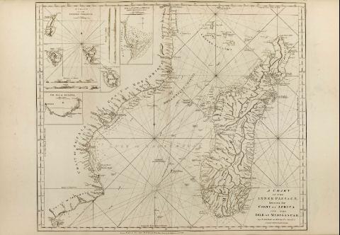
A chart of the inner passage between the coast of Africa...


 Mapas, planos y cartas náuticas
A chart of the inner passage between the coast of Africa and the isle of Madagascar : from D'Anville and D'Apres's... (1778)
Mapas, planos y cartas náuticas
A chart of the inner passage between the coast of Africa and the isle of Madagascar : from D'Anville and D'Apres's... (1778)
 Disponible Ejemplares
 Sección: Mapas, planos y cartas náuticas
Título uniforme: Madagascar. Cartas náuticas. 1:3000000 (1780)
Título: A chart of the inner passage between the coast of Africa and the isle of Madagascar : from D'Anville and D'Apres's Charts compared with the Englis's Journals
Área de datos: Escala [ca. 1:3000000] (E 31°39'46''-E 51°39'46''/S 10°00'00''-S 26°00'00'')
Publicación: London : Printed for Robt. Sayer & Jno. Bennett, 1778
Descripción física: 1 mapa ; 60 x 71 cm
Notas: Coordenadas referidas a los meridianos de Hierro y Londres
Escala gráfica de 100 leguas marinas de [= 18,4 cm]
Orientado con lis
Indica grado de declinación magnética desde diversos puntos de referencia
Presenta línea de derrota de la expedición del capitán Robert Scott en 1772
Inserta: " A chart of the Comaro islands". Escala [ca. 1:1058000]. "Foul point and bay on the East side of Madagascar" Escala [ca. 1:293000]. "The Bay of Johanna". Escala [ca. 1:327000]
Aparecen dos vistas de la costa de la isla Mayotte y otras dos de Johanna
Materia / lugar / evento: Cartas náuticas
Islas
Estrechos
Bahías
1778
Mozambique
Mayotte (Isla)
Otros autores: Mannevillette, Jean Baptiste Nicolas Denis d'Après de
Anville, Jean-Baptiste Bourguignon d', 1697-1782
Bennett, John
Sayer, Robert, 1725-1794
CDU: (691)
Tipo de publicación:
Mapas
Derechos:
Préstamo:
Disponible
