Outlines of the Physical and Political divisions of South...


 Mapas, planos y cartas náuticas
Outlines of the Physical and Political divisions of South America (1819)
Mapas, planos y cartas náuticas
Outlines of the Physical and Political divisions of South America (1819)
 Disponible Ejemplares
 Sección: Mapas, planos y cartas náuticas
Título uniforme: AMERICA DEL SUR. Mapas generales. 1819. 1:2800000 (1771-1819)
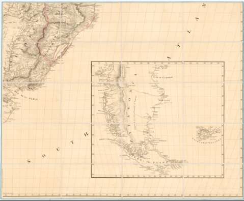
Título: Outlines of the Physical and Political divisions of South America / Delineated by A. Arrowsmith partly from scarce and original documents, published Before the year 1806 but principally from manuscript maps & surveys made between the years 1771 and 1806, corrected from accurate astronomical observations to 1810 ; Engraved by Edwd. Jones
Edición: Additions to 1814,1817,1819
Área de datos: [Ca. 1:2800000 ; proy. Eckert III u Ortelius] (O 93°- O 24°/ N 13°- 56°)
Publicación: London : Published... by A. Arrowsmith N°10 Soho Square Hidrographer to H.R.H. the Prince of wales, 1819
Descripción física: 1 mapa en 6 h. : col. montado sobre tela ; 246 x 203 cm en h de 82 x 10 cm
Tipo de contenido: Imagen cartográfica
Tipo de medio: computadora
Tipo de soporte: recurso en línea
Notas: Fecha de la edición previa a las correcciones: 4 de Enero de 1811
Escalas gráficas de 60 millas geográficas [= 4 cm], y 60 millas inglesas [= 3,5 cm]. Red geográfica de 1° en 1°
Relieve representado por normales
En la hoja inferior derecha, continuación de la parte de América del Sur comprendida entre 45° y 56° de latitud Sur
Se destaca la red hidrográfica
Límites administrativos (países, gobernaciones, capitanías...) y colonias diferenciadas por colores
Inserta: "Entrance of the River Orinoco". Escala [ca. 1:1300000], 40 millas [= 5,8 cm]. Extensa nota con advertencias para la navegación por esa zona. "Port of Angostura or St. Thome". Escala [ca. 1:17500], 400 brazas [= 4,2 cm] ; [Mapa del río Meta desde su confluencia con el Negro y Umadea al Orinoco]. Escala [ca. 1:400000], 15 leguas marinas
Materia / lugar / evento: Mapas generales
Colonias
Hidrografía
Divisiones administrativas
Fronteras
Siglo XVIII
S.XIX
América del Sur
Otros autores: Arrowsmith, Aaron, 1750-1823
Jones, Edward
CDU: 912:551.48:325.45:341.222(8-2/-5)"1819"
8
Tipo de publicación:
Mapas
Derechos:
Préstamo:
Disponible
