Military map showing the marches of the United States...


 Mapas, planos y cartas náuticas
Military map showing the marches of the United States Forces under commamd of Maj. Genl. W.T. Sherman U.S.A. During... (1865)
Mapas, planos y cartas náuticas
Military map showing the marches of the United States Forces under commamd of Maj. Genl. W.T. Sherman U.S.A. During... (1865)
 Disponible Ejemplares
 Sección: Mapas, planos y cartas náuticas
Título uniforme: ESTADOS UNIDOS. SE. Operaciones bélicas. 1:1630000 (1863-1865)
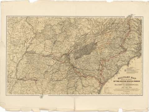
Título: Military map showing the marches of the United States Forces under commamd of Maj. Genl. W.T. Sherman U.S.A. During the years 1863, 1864, 1865 / Compiled by order of Maj. Genl W.T. Sherman U.S.A. at Head Quarters Military Division of the Mississippi under the direction of But. Maj. W.L.B. Jenney Capt. A.D.C. U.S.A. ; Drawn by Capt. William Kossak Add1 A.D.C. U.S.A. and Jonh B. Muller draughtsman St. Louis. Mo. 1865 ; Engraved at Head Qrs. Corps of Engineers, U.S.A. by H.C. Evans & F. Courtenay
Área de datos: Escala [ca. 1:1630000 ; proy. mericónica equivalente de Bonne] (O 92°45'--O 76°00'/N 38°30'--N 31°00')
Publicación: St. Louis? : [Editor no identificado], 1865
Descripción física: 1 mapa : col. ; 55 x 94 cm
Tipo de contenido: Imagen cartográfica
Tipo de medio: computadora
Tipo de soporte: recurso en línea
Notas: Comprende los estados de: Missouri, Illinois, Indiana, Kentucky, Virginia, Arkansas, Louisiana, Tennesse, Mississippi, Carolina del Norte, Carolina del Sur, Georgia y Alabama
Relación de los mapas, con el nombre de sus respectivos autores, que han servido de base para la formación de éste
Escala gráfica de 80 millas [= 7,9 cm] y nominal de 25 millas = 1 pulgada. Red geográfica de 1° en 1°
Orografía de perfil
Mediante líneas de colores se indican los movimientos de diversos cuerpos y divisiones de las tropas estadounidenses, así como la situación de las fortificaciones pertenecientes a ambos ejércitos
Materia / lugar / evento: Operaciones bélicas
Mapas generales
Estrategia militar
Fortificaciones
1865
Otros autores: Sherman, W. T
Jenney, W.L.B
Evans, H.C
Courtenay, F
Kossak, William
Muller, John B
CDU: 912:355.4:355.43:623.1(73-12)"1863/1865"
73-12
Tipo de publicación:
Mapas
Derechos:
Préstamo:
Disponible
