Map illustrating the operations of the U.S. Forces...


 Mapas, planos y cartas náuticas
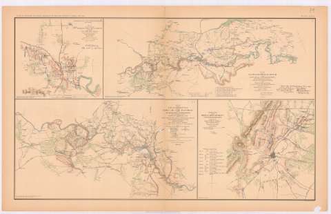
Map illustrating the operations of the U.S. Forces against Jackson, Miss. (189-?)
Mapas, planos y cartas náuticas
Map illustrating the operations of the U.S. Forces against Jackson, Miss. (189-?)
 Disponible Ejemplares
 Sección: Mapas, planos y cartas náuticas
Título: Map illustrating the operations of the U.S. Forces against Jackson, Miss. / compliled from the survey of Coypt. Pitzman May 14th - 16 th and from the survey of Officers and Assitants since july 10th ; Engineer Office H, Qrs. Expeditionary corps july 15th 1863
Área de datos: Escala [ca. 1:35763], 2 miles [= 9 cm]
Publicación: Washington : Government Printing Office, [189-?] (N.Y. [Nueva York] : Julius Bien & co.)
Descripción física: 1 mapa : col. ; 19x21 cm, en h. de 47x75 cm
Tipo de contenido: Imagen cartográfica
Tipo de medio: computadora
Tipo de soporte: recurso en línea
Notas: En : Atlas to accompany the Official Records of the Union and Confederate Armies 1861 - 1865. - Plate XXXIX, n 1
Escala gráfica además en Yards
Relieve : líneas perpendiculares normales
Orientado con flecha
Leyenda de signos
Figura en el margen inferior izquierdo : 'Series 1. Vd. XXIV. Part 2. Page 527'.
Mapa que acompaña al informe del : Maj. Gen. W.T. Sherman
Figura texto caligrafiado impreso
En : Atlas to accompany the Official Records of the Union and Confederate Armies 1861 - 1865
Materia / lugar / evento: Guerra civil
Operaciones bélicas
Estrategia militar
Baterías
Puentes
Líneas ferroviarias
Caminos
Planos de población
1863
Jackson
Estados Unidos
Otros autores: Estados Unidos. Army. Corps of Engineers. Engineer Office
CDU: 912:355.4]:[355.43+725.95+625.1+625.7](762)'1863'
912:314(762 Jackson) (084.3)
762
Tipo de publicación:
Mapas
Derechos:
Préstamo:
Disponible
