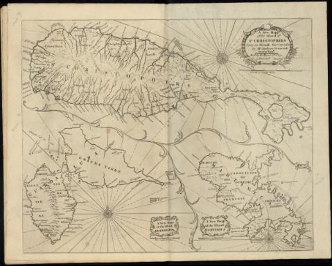
A New Mapp of the Island of St. Christophers


Sección: Mapas, planos y cartas náuticas
Título uniforme: San Cristóbal (Isla). Cartas náuticas. 1764. 1:80.000
Título: A New Mapp of the Island of St. Christophers [Mapa] / being an Actuall Survey taken by Mr. Andrew Norwood Surveyr. Genll
Área de datos: Escala [ca. 1:80000], 5 Miles [=11'5 cm]
Publicación: London : Sold by W. Mount & T. Page on Tower Hill, [1764?]
Descripción física: 1 carta náutica ; 28 X 54 cm
Notas: En: "The English Pilot. The fourth book". 15
Orientado con rosa de 32 vientos,inscrita en círculo con lis y cruz
Relieve representado por perfiles
Indica fondeaderos y arrecifes
Señala la situación de 4 fuertes y varios núcleos de población, así como los ríos
Título enmarcado en cartela barroca
Con: "A new Mapp of the Island Guardalupa". "A New Mapp of the Island Martineca"
Registros relacionados: En: The English Pilot : the fourth book, describing the West-India Navigation from Hudson's-Bay to the River Amazones .... - London : W. and J. Mount ; T. Page and Son, 1764
Materia / lugar / evento: Cartas náuticas
1764
San Cristóbal (Isla)
San Cristobal y Nieves
Otros autores: Norwood, Andrew
Jno. Mount and Tho. Page
Títulos secundarios: Título: The English Pilot. The fourth book
CDU: (729.72 San Cristóbal, isla)
Tipo de publicación:
 Mapas
Mapas
Derechos:
