Actual Survey of the coast from Arundel Haven in Sussex...


 Mapas, planos y cartas náuticas
Actual Survey of the coast from Arundel Haven in Sussex to St Aldaus in Dorsetshi : shewing all the Shoals sauds,... (17--?)
Mapas, planos y cartas náuticas
Actual Survey of the coast from Arundel Haven in Sussex to St Aldaus in Dorsetshi : shewing all the Shoals sauds,... (17--?)
 Disponible Ejemplares
 Sección: Mapas, planos y cartas náuticas
Título uniforme: LA MANCHA (Canal). Cartas náuticas (17). 1:98000
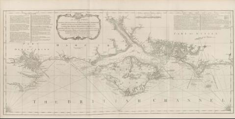
Título: Actual Survey of the coast from Arundel Haven in Sussex to St Aldaus in Dorsetshi : shewing all the Shoals sauds, Beacons, buoys, sea marks, soundings, Bays, Harbours, Havens, Rivers, Creeks, streams with the time of High Water, setting of the tides & particular Directions for sailing in at each end of the of Wight and the respective Harbours herein contained [Mapa] / Surveyed by order of the govermmnet and Dedicated to the Rt Honble the Lord of the Adminiralty by their Lordships most humble and Obedien servant; Joseph Avery; Robert Sayer and John Bennett
Área de datos: Escala [ca. 1:98000]
Publicación: London : Robert Sayer and John Bennett, 17--?
Descripción física: 1 map. ; 53 x 117 cm
Notas: En : "The East India Pilot, or Oriental Navigator", part, I, map. no. 5
Presenta la zona del Canal de la Mancha, centrada en la isla de Wight
Consta escala gráfica de 8 millas [= 13,1 cm] de longitud
Documento graduado, sin información sobre meridiano
Orientado con rosa y media lis
Presenta análisis batimétrico de la zona
Incluye amplias leyendas explicativas
Título enmarcado en cartela barroca
Otros autores: Avery, Joseph
Bennett, John
Sayer, Robert, 1725-1794
CDU: 912:551.46]:551.42(26.06)"17"
410:26.06 La Mancha
44:26.06 La Mancha
Tipo de publicación:
Mapas
Derechos:
Préstamo:
Disponible
