A chart of the Downs : with the flats of the North and...


 Mapas, planos y cartas náuticas
A chart of the Downs : with the flats of the North and South Forelands (1782)
Mapas, planos y cartas náuticas
A chart of the Downs : with the flats of the North and South Forelands (1782)
 Disponible Ejemplares
 Sección: Mapas, planos y cartas náuticas
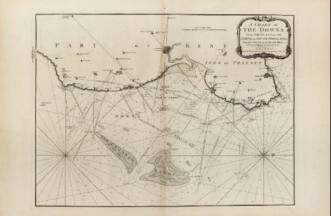
Título: A chart of the Downs : with the flats of the North and South Forelands [Mapa] / From the Observations of Joseph ross a Pilot belonging to Trinity House ; London Printed for R. Sayer & J. Bennett Fleet Street as the Act directs 20 th April 1784
Área de datos: Escala [ca. 1:40000]
Publicación: London : Robert Sayer and John Bennett, 1782
Descripción física: 1 map. ; 52 x 70 cm
Notas: En : "The East-Indian Pilot, or Oriental Navigator", part. I, map. no. 4
Consta escala gráfica de tres millas, [= 12 cm]
Presenta análisis batimétrico de la zona marítima cercana al condado de Kent
Orientado con rosa y lis
Las "Downs" son una serie de dunas que abarcan una extensión de 13 Km en la costa Este del condado inglés de Kent. Se extienden desde el N. hasta el S de Foreland y están resguardadas al Este por las arenas de Goodewin, que constituye un rompeolas natural
Indica la localización del fondeadero
Título enmarcado en cartela barroca
Materia / lugar / evento: Cartas náuticas
Fondeaderos
Otros autores: Ross, Joseph
Bennett, John
Sayer, Robert, 1725-1794
CDU: 912:551.46:627.231(410)"17"
420 Kent, Condado
Tipo de publicación:
Mapas
Derechos:
Préstamo:
Disponible
