Map of the country between Milliken's Bend, L A and...


 Mapas, planos y cartas náuticas
Map of the country between Milliken's Bend, L A and Jackson, Miss showing the recites followed by the Army of the... (189-?)
Mapas, planos y cartas náuticas
Map of the country between Milliken's Bend, L A and Jackson, Miss showing the recites followed by the Army of the... (189-?)
 Disponible Ejemplares
 Sección: Mapas, planos y cartas náuticas
Título uniforme: MISSISSIPPI (Estados Unidos) (Estado). Operaciones bélicas. 189. 1:306.539 (1863)
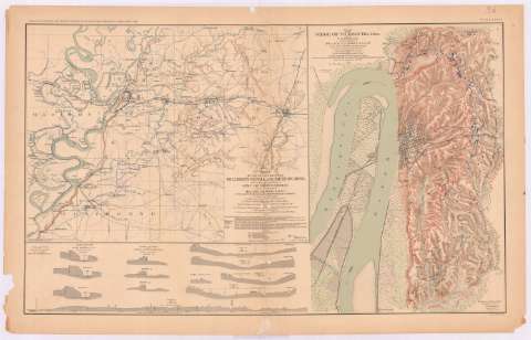
Título: Map of the country between Milliken's Bend, L A and Jackson, Miss showing the recites followed by the Army of the Tennessee under the command Maj. Gen. US Grant, US Vls. in its march from Milliken's Bend to near of Vicksburg in april and may 1863 / compiled, surveyed and drawn under the direction of Lt. Co. J.H. Wilson AIG and 1st Lient. Engrs. ; drawn by Maj. Otto H. Matz, Asst. Engr. and 1st Lient L. Helmle 3d Mo. Vol. Inft ... [et al.]
Área de datos: Escala [ca. 1:306539], 1 [= 4'2 cm]
Publicación: Washington : Government Printing Office, [189-?] (N.Y. [Nueva York] : Julius Bien & co.)
Descripción física: 1 mapa : col. ; 32x41 cm, en h. de 47x75 cm
Tipo de contenido: Imagen cartográfica
Tipo de medio: computadora
Tipo de soporte: recurso en línea
Notas: En : Atlas to accompany the Official Records of the Union and Confederate Armies 1861 - 1865. - Plate XXXVI, n 1
Relieve : sombreado
Orientado con flecha
Figura nota explicativa del mapa
Leyenda de signos utilizados
Figura en el margen inferior izquierdo : 'Serie 1 Vol XXIV part 1 page 130'
En : Atlas to accompany the Official Records of the Union and Confederate Armies 1861 - 1865
Materia / lugar / evento: Guerra civil
Operaciones bélicas
Estrategia militar
Asedios
1863
Estados Unidos
Otros autores: Wilson, James Harrison
Matz, Otto H
CDU: 912:355.4]:[355.43+355.44](775)'1863'
762
Tipo de publicación:
Mapas
Derechos:
Préstamo:
Disponible
