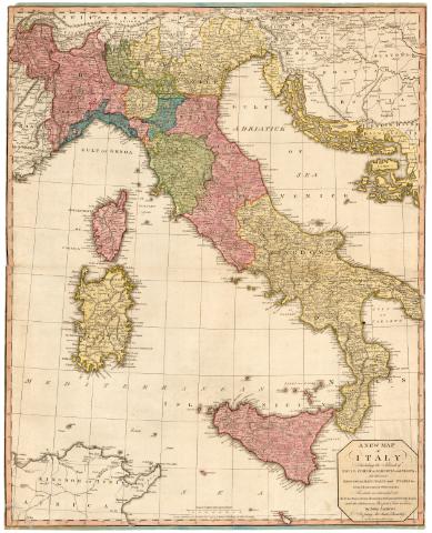
A New Map of Italy : Including the Islands of Sicily,...


-
 Mapas, planos y cartas náuticas
A New Map of Italy : Including the Islands of Sicily, Corsica, Sardinia and Malta, Divided into Kingdoms, republics... (Feby. 11 1794)
Mapas, planos y cartas náuticas
A New Map of Italy : Including the Islands of Sicily, Corsica, Sardinia and Malta, Divided into Kingdoms, republics... (Feby. 11 1794)
 Disponible Ejemplares
 Sección: Mapas, planos y cartas náuticas
Título uniforme: Italia. Mapas generales. 1794. 1:600000 (1792)
Título: A New Map of Italy : Including the Islands of Sicily, Corsica, Sardinia and Malta, Divided into Kingdoms, republics and states etc< : from Astronomical Observations In which are delineated all the cities, Towns, Rivers... with the distances in Post from Toun to Toun / by John Andrews
Área de datos: Escala [ca. 1:1600000], 80 Englisch Miles [= 8 cm] ; [proyec. cónica]
Publicación: London : Jhon Andrews, N 211 facing Air Street, Piccadilly, as the Act directs, Feby. 11 1794
Descripción física: 1 mapa : col. ; 77,6x62,3 cm
Notas: Comprende ademas de Italia, parte de Francia, Suiza y Yugoslavia
Coordenadas referidas al meridiano de Londres (E7°-E18°/N47°-N36°). Red geográfica de 1° en 1°
Relieve de perfil
Indica postas
ITLMateria / lugar / evento: Mapas generales
Divisiones administrativas
Fronteras
1792
Francia
Yugoslavia
Suiza Otros autores: Andrews, John, 1736-1809
CDU: 912:341.222(45)'1792'
(44)
(497.1)
(494)Tipo de publicación:
Mapas
Derechos:
Archivo Cartográfico de Estudios Geográficos del Centro Geográfico del EjércitoColección: PCGE — Ubicación: AR — Signatura: Ar.H-T.6-C.1-8 — Código de barras: 2212451Préstamo:
Disponible