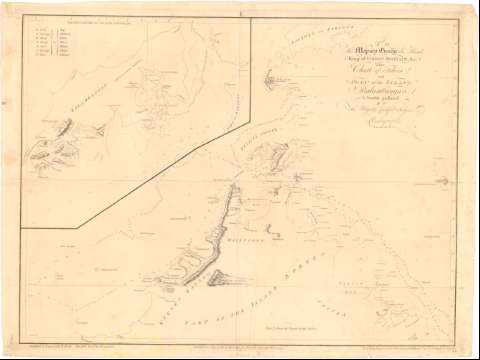
Chart of Felicia and Plan of the Island Balambangan, His


 Disponible Ejemplares
 Sección: Mapas, planos y cartas náuticas
Título uniforme: BALAMBANGAN (Sabah) (Isla). Cartas náuticas. 1:93000 (1770)
Título: Chart of Felicia and Plan of the Island Balambangan, His / Is humbly presented By... Adalrymple ; Graduated & Engrav'd by B. Henry ; the Hills Etch'd by D. Lerperiere ; the Writing Engraved by W. Whitchurch, Bartholomew Lahe, Royal Exchange, London
Área de datos: Escala [ca. 1:93000], 10 nautick miles [= 20 cm]
Publicación: [London ?] : Published according to Act of Parliament by Alexander Dalrymple, Novr. 30, 1770
Descripción física: 1 carta nautica ; 50'2x66'9 cm
Tipo de contenido: Imagen cartográfica
Tipo de medio: computadora
Tipo de soporte: recurso en línea
Notas: Dedicatoria : 'To His Majesty George the third, King of Great Britain & C.'
Relieve representado por normales
Relación de los principales accidentes geográficos indicados por clave alfabética
Otros autores: Dalrymple, Alexander
Whitchurch, William
Lerpeniere, D
Henry, B
CDU: 912:[551.46:551.42](91 Balambaugau,islas)'1770'
91 Balambaugau,islas
Tipo de publicación:
 Mapas
Mapas
Derechos:
Préstamo:
Disponible
