A Chart of the North East Coast of Great Britain...


 Mapas, planos y cartas náuticas
A Chart of the North East Coast of Great Britain including the Island of Orkney and Shetland (179- ?)
Mapas, planos y cartas náuticas
A Chart of the North East Coast of Great Britain including the Island of Orkney and Shetland (179- ?)
 Disponible Ejemplares
 Sección: Mapas, planos y cartas náuticas
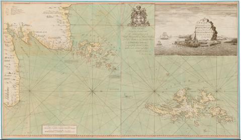
Título uniforme: Escocia (Reino Unido). Cartas náuticas. 1:370000 (179)
Título: A Chart of the North East Coast of Great Britain including the Island of Orkney and Shetland / from the best Anthonty by John Chanoler ; Andw Turnbull, 5 cu
Área de datos: Escala [ca. 1:370000], 7 German Dutch, and Danish Mils 15 to a Degrée [= 14 cm]
Publicación: London : Printed for Dand Stell, Bookseller, union Row little Towerhill as the Act Directs, [179- ?]
Descripción física: 1 carta nautica : col., montado sobre tela ; 76'5x131 cm, pleg en
Notas: Dedicatoria : 'This chart Having been honoured with the Approbation of the Right Honorable the Master Wardens and Elder Brethren of the Trinity House...'
Escala gráfica de 10 leagus of England, France 20 in a degree [= 15'5 cm]. Orientado con lis en rosa de 16 vientos prolongados
Relieve de perfil y sondas batimétricas
Indica veriles bajos, fondeaderos y dirección de la mareas con flecha
Tabla de signos convencionales para indicar bancos de arenas, dirección de las mareas
Nota en el centro del mapa para los faros
Titulo enmarcado en cartela con motivos marinos y vista
Materia / lugar / evento: Cartas náuticas
Costas
Islas
Siglo XVIII
Orcadas (Islas)
Shetland (Islas)
Escocia
Otros autores: Chanoler, John
Turnbull, Andw
Steel, David
CDU: 912:[551.46:551.468:551.42](410-328 Escocia)'1790/1799'
(410 Okney, islas)
(410 Shetland, islas)
Tipo de publicación:
Mapas
Derechos:
Préstamo:
Disponible
