Sketch of routes from Petersburg, Chester Station and...


 Mapas, planos y cartas náuticas
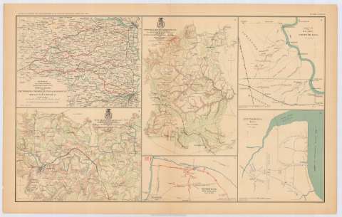
Sketch of routes from Petersburg, Chester Station and Manchester to Amelia Court - House, Va. (189-?)
Mapas, planos y cartas náuticas
Sketch of routes from Petersburg, Chester Station and Manchester to Amelia Court - House, Va. (189-?)
 Disponible Ejemplares
 Sección: Mapas, planos y cartas náuticas
Título uniforme: VIRGINIA (Estados Unidos) (Estado). Itinerarios. 189. 1:195729 (1865)
Título: Sketch of routes from Petersburg, Chester Station and Manchester to Amelia Court - House, Va. / by order of Col. T.M.R. Talcott, Com'dg. Engr. Troops A.N. Va.
Área de datos: Escala [ca. 1:195729], 9 miles [= 7,4 cm]
Publicación: Washington : Government Printing Office, [189-?] (N.Y. [Nueva York] : Julius Bien & co.)
Descripción física: 1 mapa : col. ; 21 x 28 cm en h. de 47 x 75 cm
Tipo de contenido: Imagen cartográfica
Tipo de medio: computadora
Tipo de soporte: recurso en línea
Notas: En : Atlas to accompany the Official Records of the Union and Confederate Armies 1861-1865. - Plate LXXVIII, n 1
Figura en margen inferior: Series I, vol. XLVI
Nota indicando que 'Bevill's and Goode's Bridges passable March 30th. 1865
En: Atlas to accompany the Official Records of the Union and Confederate Armies 1861-1865. nº 1
Materia / lugar / evento: Guerra civil
Mapas itinerarios
Redes de transporte
S.XIX
Petersburg
Chester (Estados Unidos)
Manchester (Estados Unidos, Virginia)
Virginia
Amelia
Estados Unidos
Otros autores: Talcott, T.M.R Colonel
CDU: 912:355.4]:656.02(755-11)'1865'
755-11
Tipo de publicación:
Mapas
Derechos:
Préstamo:
Disponible
