Columbia Prima or South America : In which it has been...


 Mapas, planos y cartas náuticas
Columbia Prima or South America : In which it has been attempted to delineate the Extent of our Knowledge of that... (June 4th. 1807)
Mapas, planos y cartas náuticas
Columbia Prima or South America : In which it has been attempted to delineate the Extent of our Knowledge of that... (June 4th. 1807)
 Disponible Ejemplares
 Sección: Mapas, planos y cartas náuticas
Título uniforme: AMERICA DEL SUR. Mapas generales. 1:3200000 (1807)
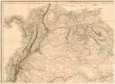
Título: Columbia Prima or South America : In which it has been attempted to delineate the Extent of our Knowledge of that Continent Extracted chiefly from the original manuscript maps of his Excellency the late Chevalier Pinto Likewise from those of Joâo Joaquin da Rocha Joao da Costa Ferreira; El Padre Francisco Manuel Sobreviela etc. and from the most authentic edited accounts of those countries / Digested i constructed by the late eminent and Learned Geographer Louis Stanislas Darcy de la Rochette ; Cooper feript. et Sculpt
Área de datos: [Ca. 1:3200000 (O 100°00'- O 15°00'/ N 12°20'- S 56°10')
Publicación: London : published by William Faden, Geographer to his Majesty and to his Royal Highefs the Prince of Wales, June 4th. 1807
Descripción física: 1 mapa en 8 h. : col, montado sobre tela ; 249 x 170 cm en h. de 63 x 86 cm
Tipo de contenido: Imagen cartográfica
Tipo de medio: computadora
Tipo de soporte: recurso en línea
Notas: Fecha de publicación en algunas de las hojas: 21 de agosto de 1807
Escalas gráficas de 80 leguas comunes españolas e inglesas de 20 al grado [= 14 cm], 80 leguas españolas y portuguesas de 7572 varas o de 17 1/² al grado, 100 leguas legales de Castilla de 5000 varas de 26 1/² al grado, 240 millas inglesa de 69 1/² al grado [= 12 cm]., 60 leguas danesas de 2000 yardas renanas y 130 horas de camino en las montañas peruanas. Proyec. sinusoidal de Sanson . Red geográfica de 5° en 5°
Relieve representado por normales
Relación de los mapas que han servido de base para la formación de éste
Clave cromática para diferenciar las posesiones holandesas, franceses, españolas y portuguesas, éstas últimas según el tratado de San Ildefonso firmado en 1777
Notas explicativas sobre el mapa, relativas a los descubrimientos, etnografía y otras características históricas y geográficas de esa zona
Indica sondas batimétricas y derrotas
Señala los límites administrativos (reino, gobernaciones, provincias y partidas) diferenciados por colores
En la hoja inferior derecha, nota manuscrita: "En obsequio de la provincia de Barcelona por su diputado en Congreso D. Francisco Miranda"
Materia / lugar / evento: Mapas generales
Tratados
Fronteras
Colonias
Divisiones administrativas
1807
América del Sur
Otros autores: La Rochette, Louis Stanislas D'Arcy de
Faden, William, 1749-1836
Cooper
CDU: 912:351.88:341.222:325.45(8-2/-5)"1807"
8
Tipo de publicación:
Mapas
Derechos:
Préstamo:
Disponible
