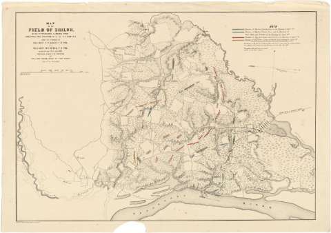
Map of the Field of Shiloh near Pittsburgh Landing, Tenn....
Sección: Mapas, planos y cartas náuticas
Título uniforme: SHILOH (Estados Unidos). (Tennessee). (Campo de). Operaciones bélicas. 1862?. 1:14500
Título: Map of the Field of Shiloh near Pittsburgh Landing, Tenn. : Shewing the positions of the U.S. Forces, under the Command of Maj. Genl. U.S. Grant U.S. Vol. and. Maj. Genl. D.C. Buell, U.S. Vol. on the 6th. and 7th of April, 1862 / Surveyed under the Direction of Col. Geo. Thom, Chief of Topl. Engrs. Dept. of the Mississippi ; Drawn by Otto H. Matz Asst. Topl. Engs
Área de datos: Escala [ca. 1:14500]
Publicación: New York : Lith. of J. Bien, [1862?]
Descripción física: 1 mapa : col. ; 44 x 63 cm
Tipo de contenido: Imagen cartográfica
Tipo de medio: computadora
Tipo de soporte: recurso en línea
Notas: Delimitación, mediante colores, de las posiciones tomadas por las tropas al mando del general Grant en las fechas indicadas en el título, figurando también los nombres de los oficiales que comandaron cada división
Escala gráfica de 1 milla [= 11'1 cm] y nominal de una pulgada por 1300 pies. Orientado con doble flecha, una con las correspondientes iniciales de cada uno de los puntos cardinales, la otra señalando el grado de declinación magnética
Orografía por normales
Materia / lugar / evento: Operaciones bélicas
Estrategia
1862
Tennessee
Otros autores: Bien, Julius, 1826-1909
Thom colonel
Matz, Otto H
CDU: 912:355.4:355.43(768)"1862"
768 Shiloh
Tipo de publicación:
![]() Mapas
Mapas
Préstamo:
![]() Disponible
Disponible


